IMAGES TAKEN NEAR TO
Swimbridge, BARNSTAPLE, EX32 0QQ
Introduction
This page details the photographs taken nearby to EX32 0QQ by members of the Geograph project.
The Geograph project started in 2005 with the aim of publishing, organising and preserving representative images for every square kilometre of Great Britain, Ireland and the Isle of Man.

There are currently over 7.5m images from over14,400 individuals and you can help contribute to the project by visiting https://www.geograph.org.uk
Image Map (Loading...)


Getting Data...Please wait
Leaflet Map data © OpenStreetMap
Images are licensed for reuse under creativecommons.org/licenses/by-sa/2.0
Notes
- Clicking on the map will re-center to the selected point.
- The higher the marker number, the further away the image location is from the centre of the postcode.
Image Listing (6 Images Found)
Images are licensed for reuse under creativecommons.org/licenses/by-sa/2.0
Image
Details
Distance
1
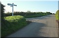
Bickell Cross
The parish boundary between Bishop's Tawton (left) and Swimbridge joins the main lane here from the left.
Image: © Derek Harper
Taken: 26 Sep 2015
0.16 miles
2

Swimbridge: grass harvest
Gathering mown grass for silage at Bickle Farm
Image: © Martin Bodman
Taken: 22 May 2007
0.16 miles
4

Lane near Bickle Farm
Taken a little north of Image]; Image] was taken a little further ahead. The parish boundary between Bishop's Tawton (left) and Swimbridge turns off the road here at the field entrance on the left.
Image: © Derek Harper
Taken: 26 Sep 2015
0.18 miles
5

A misty winter's day near Bickle Cross
Image: © Roger Cornfoot
Taken: 30 Dec 2019
0.23 miles
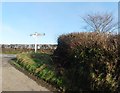
6

Lane near Bickle Farm
In the foreground is a grass bank beside the entrance the farm entrance. The road is climbing towards Halmpstone Cross.
Image: © Derek Harper
Taken: 26 Sep 2015
0.24 miles