IMAGES TAKEN NEAR TO
Swimbridge, BARNSTAPLE, EX32 0QF
Introduction
This page details the photographs taken nearby to EX32 0QF by members of the Geograph project.
The Geograph project started in 2005 with the aim of publishing, organising and preserving representative images for every square kilometre of Great Britain, Ireland and the Isle of Man.

There are currently over 7.5m images from over14,400 individuals and you can help contribute to the project by visiting https://www.geograph.org.uk
Image Map
Images are licensed for reuse under creativecommons.org/licenses/by-sa/2.0
Notes
- Clicking on the map will re-center to the selected point.
- The higher the marker number, the further away the image location is from the centre of the postcode.
Image Listing (3 Images Found)
Images are licensed for reuse under creativecommons.org/licenses/by-sa/2.0
Image
Details
Distance
1
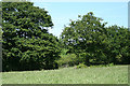
Swimbridge: field by the edge of a wood
Looking north east
Image: © Martin Bodman
Taken: 22 May 2007
0.19 miles
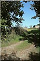
2

Lane from Possession Cross
From the same spot as Image], looking to the left along the lane to Swimbridge.
Image: © Derek Harper
Taken: 26 Sep 2015
0.21 miles
3
Track to barn near Possession Cross
The track (not a right of way) leaves the lane north of the cross just beside Swimbridge Footpath 10.
Image: © Derek Harper
Taken: 26 Sep 2015
0.25 miles