IMAGES TAKEN NEAR TO
Mill Hill, BARNSTAPLE, EX32 0NS
Introduction
This page details the photographs taken nearby to Mill Hill, EX32 0NS by members of the Geograph project.
The Geograph project started in 2005 with the aim of publishing, organising and preserving representative images for every square kilometre of Great Britain, Ireland and the Isle of Man.

There are currently over 7.5m images from over14,400 individuals and you can help contribute to the project by visiting https://www.geograph.org.uk
Image Map
Images are licensed for reuse under creativecommons.org/licenses/by-sa/2.0
Notes
- Clicking on the map will re-center to the selected point.
- The higher the marker number, the further away the image location is from the centre of the postcode.
Image Listing (5 Images Found)
Images are licensed for reuse under creativecommons.org/licenses/by-sa/2.0
Image
Details
Distance
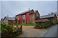
2
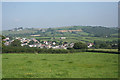
Landkey: towards Landkey Newland
View from Stony Lane End. Near the skyline, to the left, is Acland Barton. See Image The North Devon Link Road runs beyond Landkey, hidden by trees, on the alignment of the old Taunton-Barnstaple railway
Image: © Martin Bodman
Taken: 13 Sep 2007
0.06 miles
3
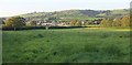
Towards Landkey
Across grass fields from Stony Lane End.
Image: © Derek Harper
Taken: 26 Sep 2015
0.09 miles
4
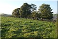
Trees near Stony Lane End
Along a field boundary and seen from Stony Lane near Moorland House.
Image: © Derek Harper
Taken: 26 Sep 2015
0.24 miles
5
Landkey : Newland Park
A house on Newland Park Road.
Image: © Lewis Clarke
Taken: 14 Mar 2020
0.25 miles