IMAGES TAKEN NEAR TO
Blakeshill Road, BARNSTAPLE, EX32 0NF
Introduction
This page details the photographs taken nearby to Blakeshill Road, EX32 0NF by members of the Geograph project.
The Geograph project started in 2005 with the aim of publishing, organising and preserving representative images for every square kilometre of Great Britain, Ireland and the Isle of Man.

There are currently over 7.5m images from over14,400 individuals and you can help contribute to the project by visiting https://www.geograph.org.uk
Image Map (Loading...)


Getting Data...Please wait
Leaflet Map data © OpenStreetMap
Images are licensed for reuse under creativecommons.org/licenses/by-sa/2.0
Notes
- Clicking on the map will re-center to the selected point.
- The higher the marker number, the further away the image location is from the centre of the postcode.
Image Listing (46 Images Found)
Images are licensed for reuse under creativecommons.org/licenses/by-sa/2.0
Image
Details
Distance
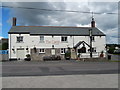
1

Blakes Hill Road, Landkey
With the Castle Inn Image in the foreground, where the bus will stop and take me home, or at least to Exeter, eventually.
Image: © Derek Harper
Taken: 26 Sep 2015
0.02 miles
2

Pastel colours
A variety of coloured houses in Blakes Hill Road, Landkey.
Image: © Anthony Vosper
Taken: 9 Mar 2019
0.02 miles
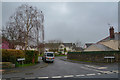
3
Castle Public House, Blakes Hill Road, Landkey
Since the Ring o' Bells closed, now the only pub in Landkey village.
There is a skittle alley at the rear.
Image: © Charles Fowler
Taken: 3 Aug 2013
0.02 miles

5

Landkey : Blakes Hill Road
Looking along Blakes Hill Road in Landkey.
Image: © Lewis Clarke
Taken: 14 Mar 2020
0.03 miles
6

Landkey : Blakes Hill Road
Looking along Blakes Hill Road in Landkey.
Image: © Lewis Clarke
Taken: 14 Mar 2020
0.05 miles
7

Landkey : Willows Tearoom
A cafe in Landkey.
Image: © Lewis Clarke
Taken: 18 May 2021
0.05 miles
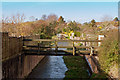
8
The confluence of waterways to form Venn Stream
Just beyond view is a mill leat which rejoins the stream a little further on.
Image: © Roger A Smith
Taken: 23 Nov 2012
0.06 miles
9
The water which passed under Blakes Hill Road heading towards Venn Stream
Image: © Roger A Smith
Taken: 23 Nov 2012
0.06 miles
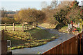
10
Landkey : South Hayes Copse
South Hayes Copse off Blakes Hill Road.
Image: © Lewis Clarke
Taken: 14 Mar 2020
0.07 miles