IMAGES TAKEN NEAR TO
Portmore, BARNSTAPLE, EX32 0HR
Introduction
This page details the photographs taken nearby to EX32 0HR by members of the Geograph project.
The Geograph project started in 2005 with the aim of publishing, organising and preserving representative images for every square kilometre of Great Britain, Ireland and the Isle of Man.

There are currently over 7.5m images from over14,400 individuals and you can help contribute to the project by visiting https://www.geograph.org.uk
Image Map (Loading...)


Getting Data...Please wait
Leaflet Map data © OpenStreetMap
Images are licensed for reuse under creativecommons.org/licenses/by-sa/2.0
Notes
- Clicking on the map will re-center to the selected point.
- The higher the marker number, the further away the image location is from the centre of the postcode.
Image Listing (9 Images Found)
Images are licensed for reuse under creativecommons.org/licenses/by-sa/2.0
Image
Details
Distance
1
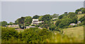
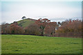
Hill Farm, Little Hill Farm and Old Hill Farm
Image: © Roger A Smith
Taken: 25 May 2023
0.01 miles

4
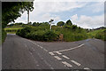
A junction on Venn Road near Hill Farm
Image: © Roger A Smith
Taken: 25 Jun 2012
0.16 miles
5

Jon Beer Auto Services, Cradleman's Cross
Image: © Roger Cornfoot
Taken: 30 Dec 2019
0.19 miles
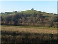
6
Portmore Golf Park, Cradlemans Cross and Codden Hill
Cradlemans Cross on Mount Sandford Road is in the centre of the image. The monument on Codden Hill can be seen above and to the right.
Image: © Roger A Smith
Taken: 27 Apr 2012
0.21 miles
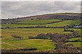
8
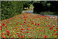
Wild flowers on the verge at the entrance to Portmore Golf Club on the Landkey Road
Image: © Roger A Smith
Taken: 19 Aug 2019
0.23 miles
