IMAGES TAKEN NEAR TO
Bishops Tawton, BARNSTAPLE, EX32 0EU
Introduction
This page details the photographs taken nearby to EX32 0EU by members of the Geograph project.
The Geograph project started in 2005 with the aim of publishing, organising and preserving representative images for every square kilometre of Great Britain, Ireland and the Isle of Man.

There are currently over 7.5m images from over14,400 individuals and you can help contribute to the project by visiting https://www.geograph.org.uk
Image Map (Loading...)


Getting Data...Please wait
Leaflet Map data © OpenStreetMap
Images are licensed for reuse under creativecommons.org/licenses/by-sa/2.0
Notes
- Clicking on the map will re-center to the selected point.
- The higher the marker number, the further away the image location is from the centre of the postcode.
Image Listing (6 Images Found)
Images are licensed for reuse under creativecommons.org/licenses/by-sa/2.0
Image
Details
Distance
1
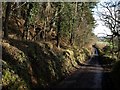
Horestone Copse
A small wood riddled with quarries, and currently with snowdrops in bloom, on the valley side of the River Taw. The lane is between Herner and Hawkridge Cross.
Image: © Derek Harper
Taken: 24 Jan 2008
0.06 miles
2
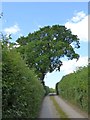
Tree shaped by the wind and traffic at Horestone
On the minor road north-west of Horestone Cottages, which appear to be the only houses in this gridsquare
Image: © David Smith
Taken: 8 Jun 2015
0.09 miles
3
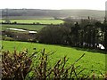
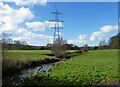
Taw valley near Horestone Apiary
The flood plain, some 700 metres wide here, is about 10 metres above sea level. Small lakes have formed in an abandoned stretch of the river bed on the left. The woodland across the field is a narrow belt occupying a steep section of valley side, doubtless a former river cliff. The pylon is close to the Tarka railway line, which runs along the dark embankment with bushes. View, over a hedge, from the lane between Herner and Hawkridge Cross.
Image: © Derek Harper
Taken: 24 Jan 2008
0.13 miles
4
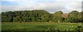
Taw valley at Horestone
From a train on the railway line between Chapelton and Umberleigh. The wood is Horestone Copse.
Image: © Derek Harper
Taken: 27 Sep 2016
0.23 miles
6
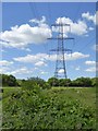
Pylons and power lines near Hawkridge Bridge
The second pylon is on the further bank of the River Taw; the river flows on the far side of the trees beyond the first pylon
Image: © David Smith
Taken: 8 Jun 2015
0.25 miles