IMAGES TAKEN NEAR TO
Challacombe, BARNSTAPLE, EX31 4TW
Introduction
This page details the photographs taken nearby to EX31 4TW by members of the Geograph project.
The Geograph project started in 2005 with the aim of publishing, organising and preserving representative images for every square kilometre of Great Britain, Ireland and the Isle of Man.

There are currently over 7.5m images from over14,400 individuals and you can help contribute to the project by visiting https://www.geograph.org.uk
Image Map
Images are licensed for reuse under creativecommons.org/licenses/by-sa/2.0
Notes
- Clicking on the map will re-center to the selected point.
- The higher the marker number, the further away the image location is from the centre of the postcode.
Image Listing (78 Images Found)
Images are licensed for reuse under creativecommons.org/licenses/by-sa/2.0
Image
Details
Distance
1
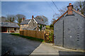
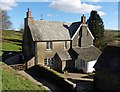
Barton Town : Barton Town Farm
Buildings at Barton Town Farm.
Image: © Lewis Clarke
Taken: 31 Mar 2021
0.01 miles
3
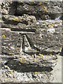
Ordnance Survey Cut Mark
This OS cut mark can be found on the roadside farm building. It marks a point 274.957m above mean sea level.
Image: © Adrian Dust
Taken: 22 Apr 2015
0.02 miles
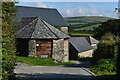
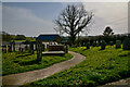
5
Challacombe : Barton Town Scenery
Looking across to the small hamlet.
Image: © Lewis Clarke
Taken: 31 Mar 2021
0.02 miles
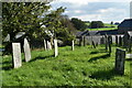
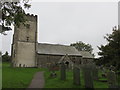
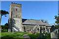
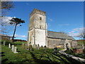
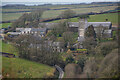
7
Barton Town : Holy Trinity Church
The building dates from the 13th century, but was largely restored in the middle of the 19th century.
Image: © Lewis Clarke
Taken: 31 Mar 2021
0.03 miles