IMAGES TAKEN NEAR TO
Bratton Fleming, BARNSTAPLE, EX31 4TF
Introduction
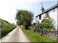
This page details the photographs taken nearby to EX31 4TF by members of the Geograph project.
The Geograph project started in 2005 with the aim of publishing, organising and preserving representative images for every square kilometre of Great Britain, Ireland and the Isle of Man.

There are currently over 7.5m images from over14,400 individuals and you can help contribute to the project by visiting https://www.geograph.org.uk
Image Map (Loading...)


Getting Data...Please wait
Leaflet Map data © OpenStreetMap
Images are licensed for reuse under creativecommons.org/licenses/by-sa/2.0
Notes
- Clicking on the map will re-center to the selected point.
- The higher the marker number, the further away the image location is from the centre of the postcode.
Image Listing (2 Images Found)
Images are licensed for reuse under creativecommons.org/licenses/by-sa/2.0
Image
Details
Distance
2
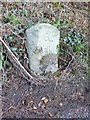
Old Milestone east of Bratton Cross
Carved stone post by the UC road, in parish of BRATTON FLEMING (NORTH DEVON District), opposite lane to Chumhill, 50m West of Bratton Cross, on bank close to road edge, on South side of road. Barum tombstone, erected by the Barnstaple turnpike trust in the 19th century.
Inscription reads:-
6
BARUM
Milestone Society National ID: DV_BSIFc06
Image: © Alan Rosevear
Taken: 8 Dec 2012
0.24 miles