IMAGES TAKEN NEAR TO
Bratton Fleming, BARNSTAPLE, EX31 4RY
Introduction
This page details the photographs taken nearby to EX31 4RY by members of the Geograph project.
The Geograph project started in 2005 with the aim of publishing, organising and preserving representative images for every square kilometre of Great Britain, Ireland and the Isle of Man.

There are currently over 7.5m images from over14,400 individuals and you can help contribute to the project by visiting https://www.geograph.org.uk
Image Map
Images are licensed for reuse under creativecommons.org/licenses/by-sa/2.0
Notes
- Clicking on the map will re-center to the selected point.
- The higher the marker number, the further away the image location is from the centre of the postcode.
Image Listing (79 Images Found)
Images are licensed for reuse under creativecommons.org/licenses/by-sa/2.0
Image
Details
Distance
1
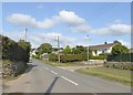
Junction with Fairfield, Bratton Fleming
Modern housing on the edge of the village
Image: © David Smith
Taken: 29 Aug 2018
0.04 miles
2
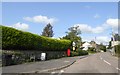
Main street of Bratton Fleming
A little street furniture by this wide pavement; rubbish bin, seat, advert, postbox and road sign
Image: © David Smith
Taken: 29 Aug 2018
0.09 miles


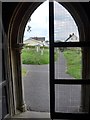
5
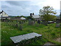
St Peter, Bratton Fleming: churchyard (d)
Image: © Basher Eyre
Taken: 25 May 2015
0.14 miles
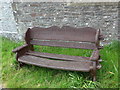
6
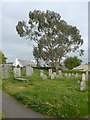
St Peter, Bratton Fleming: churchyard (e)
Image: © Basher Eyre
Taken: 25 May 2015
0.14 miles
7

St Peter, Bratton Fleming: churchyard (f)
Image: © Basher Eyre
Taken: 25 May 2015
0.14 miles
8
St Peter, Bratton Fleming: churchyard (g)
Image: © Basher Eyre
Taken: 25 May 2015
0.14 miles
9

St Peter, Bratton Fleming: churchyard (h)
Image: © Basher Eyre
Taken: 25 May 2015
0.14 miles
10
St Peter, Bratton Fleming: churchyard (j)
Image: © Basher Eyre
Taken: 25 May 2015
0.14 miles