IMAGES TAKEN NEAR TO
Parracombe, BARNSTAPLE, EX31 4QQ
Introduction
This page details the photographs taken nearby to EX31 4QQ by members of the Geograph project.
The Geograph project started in 2005 with the aim of publishing, organising and preserving representative images for every square kilometre of Great Britain, Ireland and the Isle of Man.

There are currently over 7.5m images from over14,400 individuals and you can help contribute to the project by visiting https://www.geograph.org.uk
Image Map
Images are licensed for reuse under creativecommons.org/licenses/by-sa/2.0
Notes
- Clicking on the map will re-center to the selected point.
- The higher the marker number, the further away the image location is from the centre of the postcode.
Image Listing (81 Images Found)
Images are licensed for reuse under creativecommons.org/licenses/by-sa/2.0
Image
Details
Distance
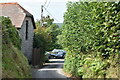
1
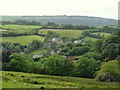
Parracombe church and surrounding countryside.
Image: © Roger A Smith
Taken: 19 Jun 2009
0.05 miles
2
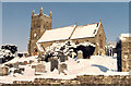
Christ Church, Parracombe
The new Church built in 1878 when St.Petrocks Churchtown was abandoned.
Image: © Peter Roberts
Taken: 4 Apr 2002
0.05 miles
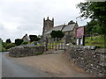
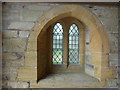
3

Interior of Christ's Church, Parracombe
Image: © Derek Voller
Taken: 19 Sep 2008
0.05 miles
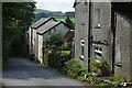
4

Entrance porch and door, Christ's Church, Parracombe
Image: © Derek Voller
Taken: 19 Sep 2008
0.05 miles
9
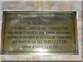
Christ Church, Parracombe: memorial (D)
Image: © Basher Eyre
Taken: 25 May 2015
0.07 miles
10
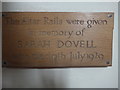
Christ Church, Parracombe: memorial (C)
Image: © Basher Eyre
Taken: 25 May 2015
0.07 miles