IMAGES TAKEN NEAR TO
Trentishoe, BARNSTAPLE, EX31 4QD
Introduction
This page details the photographs taken nearby to Trentishoe, EX31 4QD by members of the Geograph project.
The Geograph project started in 2005 with the aim of publishing, organising and preserving representative images for every square kilometre of Great Britain, Ireland and the Isle of Man.

There are currently over 7.5m images from over14,400 individuals and you can help contribute to the project by visiting https://www.geograph.org.uk
Image Map (Loading...)


Getting Data...Please wait
Leaflet Map data © OpenStreetMap
Images are licensed for reuse under creativecommons.org/licenses/by-sa/2.0
Notes
- Clicking on the map will re-center to the selected point.
- The higher the marker number, the further away the image location is from the centre of the postcode.
Image Listing (19 Images Found)
Images are licensed for reuse under creativecommons.org/licenses/by-sa/2.0
Image
Details
Distance

2
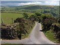
Country lane
Beautiful Exmoor landscape
Image: © Mike Woolgar
Taken: 14 Oct 2007
0.07 miles

4
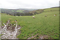
Sheep near South Dean Corner
The roofs of South Dean Farm can be seen ahead, where the land descends towards Trentishoe Water.
Image: © Bill Boaden
Taken: 5 Mar 2019
0.11 miles
5
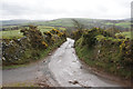
South Dean Lane
A typical Devon lane with high walls on each side.
Image: © Bill Boaden
Taken: 5 Mar 2019
0.11 miles

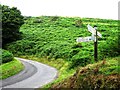
7
Rhydda Banks Cross
Road junction near Trentishoe.
Image: © Wayland Smith
Taken: 9 Apr 2022
0.13 miles
9
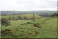
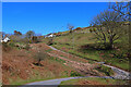
Former field boundary near Trentishoe
The solid Devon wall has been allowed to subside.
Image: © Bill Boaden
Taken: 5 Mar 2019
0.15 miles
10
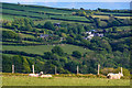
Trentishoe : Grassy Field & Sheep
Sheep in a grassy field.
Image: © Lewis Clarke
Taken: 13 May 2020
0.18 miles