IMAGES TAKEN NEAR TO
Trentishoe, BARNSTAPLE, EX31 4PJ
Introduction
This page details the photographs taken nearby to Trentishoe, EX31 4PJ by members of the Geograph project.
The Geograph project started in 2005 with the aim of publishing, organising and preserving representative images for every square kilometre of Great Britain, Ireland and the Isle of Man.

There are currently over 7.5m images from over14,400 individuals and you can help contribute to the project by visiting https://www.geograph.org.uk
Image Map
Images are licensed for reuse under creativecommons.org/licenses/by-sa/2.0
Notes
- Clicking on the map will re-center to the selected point.
- The higher the marker number, the further away the image location is from the centre of the postcode.
Image Listing (7 Images Found)
Images are licensed for reuse under creativecommons.org/licenses/by-sa/2.0
Image
Details
Distance
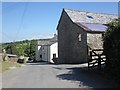
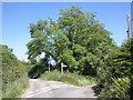
3
Lower Dean Farm
Dean Riding Stables occupy the building on the right and the signpost indicates Parracombe 2½ miles to the right (east), Trentishoe and Combe Martin both 4 miles to the left (west).
Image: © Roger Gittins
Taken: 23 May 2007
0.08 miles
6
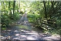
Ford at Dean
This ford is found on Dean Water at Dean.
Image: © John Walton
Taken: 24 Sep 2014
0.24 miles
