IMAGES TAKEN NEAR TO
East Down, BARNSTAPLE, EX31 4LS
Introduction
This page details the photographs taken nearby to EX31 4LS by members of the Geograph project.
The Geograph project started in 2005 with the aim of publishing, organising and preserving representative images for every square kilometre of Great Britain, Ireland and the Isle of Man.

There are currently over 7.5m images from over14,400 individuals and you can help contribute to the project by visiting https://www.geograph.org.uk
Image Map
Images are licensed for reuse under creativecommons.org/licenses/by-sa/2.0
Notes
- Clicking on the map will re-center to the selected point.
- The higher the marker number, the further away the image location is from the centre of the postcode.
Image Listing (15 Images Found)
Images are licensed for reuse under creativecommons.org/licenses/by-sa/2.0
Image
Details
Distance
1
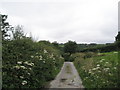
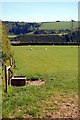
Road from Churchill descends down into Clifton
Image: © Basher Eyre
Taken: 6 Aug 2008
0.14 miles
2
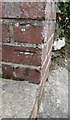
Ordnance Survey Cut Mark
This OS cut mark can be found on the brick Letter Box pillar. It marks a point 131.966m above mean sea level.
Image: © Adrian Dust
Taken: 7 Jul 2016
0.16 miles
3
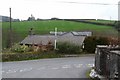
Clifton at the junction with the roads to Churchill & East Down.
Image: © Roger A Smith
Taken: 17 Apr 2009
0.17 miles
5
Churchill Wood
View from Dudmoor Lane to Churchill Wood with Clifton in the valley.
Image: © Roger Gittins
Taken: 23 May 2007
0.20 miles
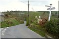
6

Brockham Bridge where the road to Clifton and East Down leaves the A39.
Image: © Roger A Smith
Taken: 17 Apr 2009
0.22 miles
7
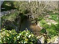
The view upstream from Brockham Bridge on the River Yeo
This River Yeo is one of four in Devon with the same name (that I am aware of). It starts near Berry Down and feeds into the Taw estuary at Barnstaple.
Image: © Roger A Smith
Taken: 12 May 2010
0.22 miles

9

Brockham Bridge on the River Yeo
This River Yeo is one of four in Devon with the same name (that I am aware of). It starts near Berry Down and feeds into the Taw estuary at Barnstaple.
Image: © Roger A Smith
Taken: 17 Apr 2009
0.24 miles
10

Brockham Bridge where the road from Clifton meets the A39.
Image: © Roger A Smith
Taken: 17 Apr 2009
0.24 miles