IMAGES TAKEN NEAR TO
East Down, BARNSTAPLE, EX31 4LL
Introduction
This page details the photographs taken nearby to EX31 4LL by members of the Geograph project.
The Geograph project started in 2005 with the aim of publishing, organising and preserving representative images for every square kilometre of Great Britain, Ireland and the Isle of Man.

There are currently over 7.5m images from over14,400 individuals and you can help contribute to the project by visiting https://www.geograph.org.uk
Image Map
Images are licensed for reuse under creativecommons.org/licenses/by-sa/2.0
Notes
- Clicking on the map will re-center to the selected point.
- The higher the marker number, the further away the image location is from the centre of the postcode.
Image Listing (4 Images Found)
Images are licensed for reuse under creativecommons.org/licenses/by-sa/2.0
Image
Details
Distance
3
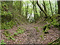
The footpath through Woolley Woods which leaves the A39 only to rejoin it further on.
Image: © Roger A Smith
Taken: 9 May 2009
0.22 miles
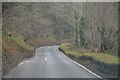
4
East Down : A39
Looking along the A39.
Image: © Lewis Clarke
Taken: 21 Dec 2021
0.24 miles