IMAGES TAKEN NEAR TO
Shirwell Road, BARNSTAPLE, EX31 4JH
Introduction
This page details the photographs taken nearby to Shirwell Road, EX31 4JH by members of the Geograph project.
The Geograph project started in 2005 with the aim of publishing, organising and preserving representative images for every square kilometre of Great Britain, Ireland and the Isle of Man.

There are currently over 7.5m images from over14,400 individuals and you can help contribute to the project by visiting https://www.geograph.org.uk
Image Map
Images are licensed for reuse under creativecommons.org/licenses/by-sa/2.0
Notes
- Clicking on the map will re-center to the selected point.
- The higher the marker number, the further away the image location is from the centre of the postcode.
Image Listing (25 Images Found)
Images are licensed for reuse under creativecommons.org/licenses/by-sa/2.0
Image
Details
Distance
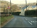
1
Countryside near the junction of the B3230 & A39
Image: © Roger A Smith
Taken: 29 Apr 2008
0.10 miles
2

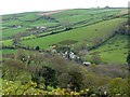
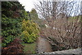
Shirwell : Countryside Scenery
Looking across the countryside.
Image: © Lewis Clarke
Taken: 21 Dec 2021
0.12 miles
3
The B3230 approaching Blachford House with Blakewell fisheries out of view to the left
Image: © Roger A Smith
Taken: 11 Mar 2010
0.15 miles
4

The view downstream on Bradiford Water from a bridge at Blakewell
Image: © Roger A Smith
Taken: 7 Jan 2011
0.19 miles
5

A bridge which carries the B3230 over a stream near Blakewell
This stream joins Bradiford Water.
Image: © Roger A Smith
Taken: 7 Jan 2011
0.19 miles
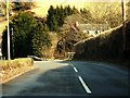
7

The B3230 passing the road to Blakewell
Image: © Roger A Smith
Taken: 7 Jan 2011
0.20 miles
9
The upstream view from a bridge on the B3230 near Blakewell
Image: © Roger A Smith
Taken: 7 Jan 2011
0.20 miles
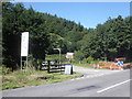
10

A bridge over Bradiford Water near Blakewell as seen from upstream
Two days after prolonged rainfall. See also: Image
Image: © Roger A Smith
Taken: 24 Dec 2012
0.21 miles