IMAGES TAKEN NEAR TO
Bittadon, BARNSTAPLE, EX31 4HN
Introduction
This page details the photographs taken nearby to EX31 4HN by members of the Geograph project.
The Geograph project started in 2005 with the aim of publishing, organising and preserving representative images for every square kilometre of Great Britain, Ireland and the Isle of Man.

There are currently over 7.5m images from over14,400 individuals and you can help contribute to the project by visiting https://www.geograph.org.uk
Image Map
Images are licensed for reuse under creativecommons.org/licenses/by-sa/2.0
Notes
- Clicking on the map will re-center to the selected point.
- The higher the marker number, the further away the image location is from the centre of the postcode.
Image Listing (5 Images Found)
Images are licensed for reuse under creativecommons.org/licenses/by-sa/2.0
Image
Details
Distance
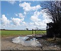
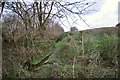
2
A stream which runs parallel to the river Caen on Frog Moor
See also: Image
Image: © Roger A Smith
Taken: 23 Nov 2010
0.22 miles
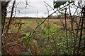
4
The river Caen descending from its source on Frog Moor
On the other side of the ridge to the left of the water is another stream. Careful study of various maps leads me to conclude that this is not the actual river.
See also: Image
Image: © Roger A Smith
Taken: 23 Nov 2010
0.24 miles
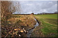
5
A stream leaving Frog Moor just prior to passing under the B3230
See also: Image
Image: © Roger A Smith
Taken: 23 Nov 2010
0.25 miles