IMAGES TAKEN NEAR TO
Bittadon, BARNSTAPLE, EX31 4HL
Introduction
This page details the photographs taken nearby to EX31 4HL by members of the Geograph project.
The Geograph project started in 2005 with the aim of publishing, organising and preserving representative images for every square kilometre of Great Britain, Ireland and the Isle of Man.

There are currently over 7.5m images from over14,400 individuals and you can help contribute to the project by visiting https://www.geograph.org.uk
Image Map (Loading...)


Getting Data...Please wait
Leaflet Map data © OpenStreetMap
Images are licensed for reuse under creativecommons.org/licenses/by-sa/2.0
Notes
- Clicking on the map will re-center to the selected point.
- The higher the marker number, the further away the image location is from the centre of the postcode.
Image Listing (9 Images Found)
Images are licensed for reuse under creativecommons.org/licenses/by-sa/2.0
Image
Details
Distance
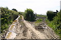
1
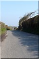
Windswept tree on the road approaching Burland Farm
Image: © Roger A Smith
Taken: 22 Apr 2008
0.15 miles
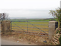
3
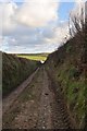
A track which runs across Fullabrook Down to Burland Cross
Image: © Roger A Smith
Taken: 25 Nov 2010
0.19 miles
4
Turbine Blades arriving at the Fullabrook Down Wind Farm
Image: © Roger A Smith
Taken: 19 Apr 2011
0.20 miles
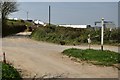
5
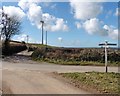
Public byway off Burland Cross
Public byway off Burland Cross
Image: © Shaun Ferguson
Taken: 31 Jul 2007
0.22 miles
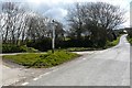
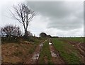
7
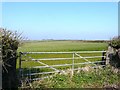
Part of Metcombe Down seen from the road between Horedown Gate and Prixford
Image: © Roger A Smith
Taken: 22 Apr 2008
0.24 miles