IMAGES TAKEN NEAR TO
Beara Lane, BARNSTAPLE, EX31 4ER
Introduction
This page details the photographs taken nearby to Beara Lane, EX31 4ER by members of the Geograph project.
The Geograph project started in 2005 with the aim of publishing, organising and preserving representative images for every square kilometre of Great Britain, Ireland and the Isle of Man.

There are currently over 7.5m images from over14,400 individuals and you can help contribute to the project by visiting https://www.geograph.org.uk
Image Map
Images are licensed for reuse under creativecommons.org/licenses/by-sa/2.0
Notes
- Clicking on the map will re-center to the selected point.
- The higher the marker number, the further away the image location is from the centre of the postcode.
Image Listing (85 Images Found)
Images are licensed for reuse under creativecommons.org/licenses/by-sa/2.0
Image
Details
Distance
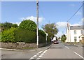
1

Electricity sub-station, Bratton Fleming
Image: © Roger Cornfoot
Taken: 22 Oct 2011
0.04 miles
2
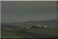
Bratton Flemming and the distant hills of Exmoor
Image: © Roger A Smith
Taken: 3 Apr 2011
0.07 miles

6

A view towards a distant Bratton Fleming from the monument on Codden Beacon
See Also: Image
Image: © Roger A Smith
Taken: 10 Mar 2010
0.10 miles
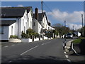
7
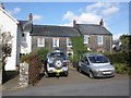
Bus stop by Three Ways, Bratton Fleming
Image: © David Smith
Taken: 29 Aug 2018
0.15 miles
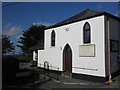
8
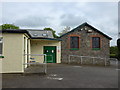
St Peter, Bratton Fleming: church hall car park
Image: © Basher Eyre
Taken: 25 May 2015
0.16 miles
10
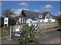
Community Primary School, Bratton Fleming
Image: © Roger Cornfoot
Taken: 22 Oct 2011
0.17 miles