IMAGES TAKEN NEAR TO
Marwood, BARNSTAPLE, EX31 4EH
Introduction
This page details the photographs taken nearby to EX31 4EH by members of the Geograph project.
The Geograph project started in 2005 with the aim of publishing, organising and preserving representative images for every square kilometre of Great Britain, Ireland and the Isle of Man.

There are currently over 7.5m images from over14,400 individuals and you can help contribute to the project by visiting https://www.geograph.org.uk
Image Map
Images are licensed for reuse under creativecommons.org/licenses/by-sa/2.0
Notes
- Clicking on the map will re-center to the selected point.
- The higher the marker number, the further away the image location is from the centre of the postcode.
Image Listing (17 Images Found)
Images are licensed for reuse under creativecommons.org/licenses/by-sa/2.0
Image
Details
Distance

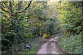
4
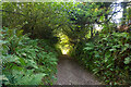
Beara : Track
A track heads down towards Beara Farm.
Image: © Lewis Clarke
Taken: 21 Sep 2021
0.05 miles
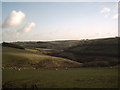
5
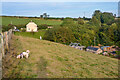
Beara : Grassy Field
A grassy field with a right of way heading through.
Image: © Lewis Clarke
Taken: 21 Sep 2021
0.06 miles
6
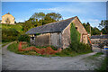
Beara : Beara Farm
Looking towards farm buildings along the track.
Image: © Lewis Clarke
Taken: 21 Sep 2021
0.06 miles
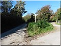
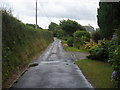
7

Beara : Country Lane
A road junction in the countryside.
Image: © Lewis Clarke
Taken: 21 Sep 2021
0.06 miles
8
Farmland near Beara
Taken on the footpath from Beara to Westcott Barton.
Image: © Grant Sherman
Taken: 19 Dec 2005
0.06 miles
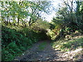
9
Lane in Beara
Lane in Beara heading to Whitehall
Image: © Shaun Ferguson
Taken: 6 Jul 2011
0.08 miles
10
Beara : Country Lane
Looking along the lane.
Image: © Lewis Clarke
Taken: 21 Sep 2021
0.10 miles