IMAGES TAKEN NEAR TO
Ashford, BARNSTAPLE, EX31 4DA
Introduction
This page details the photographs taken nearby to EX31 4DA by members of the Geograph project.
The Geograph project started in 2005 with the aim of publishing, organising and preserving representative images for every square kilometre of Great Britain, Ireland and the Isle of Man.

There are currently over 7.5m images from over14,400 individuals and you can help contribute to the project by visiting https://www.geograph.org.uk
Image Map
Images are licensed for reuse under creativecommons.org/licenses/by-sa/2.0
Notes
- Clicking on the map will re-center to the selected point.
- The higher the marker number, the further away the image location is from the centre of the postcode.
Image Listing (4 Images Found)
Images are licensed for reuse under creativecommons.org/licenses/by-sa/2.0
Image
Details
Distance
1
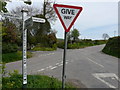
Springfield New Lodge Cross, between Ashford & Prixford
Image: © Roger A Smith
Taken: 26 Apr 2008
0.01 miles
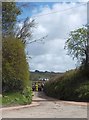
3
Lookout Cottages near the junction of Upcott Hill with Gratton Lane
Lookout Cottages are just above centre. The house to the left is on Field Lane in Ashford. The photographer was standing in Fremington near the junction of Beechfied Road with Yelland Road.
Image: © Roger A Smith
Taken: 30 Apr 2020
0.09 miles
4
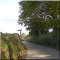
Where footpaths cross the road north of Ashford
Two paths (one signpost) from the south, and one from the north meet the Old Barnstaple Road north of the village of Ashford
Image: © David Smith
Taken: 9 Oct 2015
0.24 miles