IMAGES TAKEN NEAR TO
Newton Tracey, BARNSTAPLE, EX31 3PW
Introduction
This page details the photographs taken nearby to EX31 3PW by members of the Geograph project.
The Geograph project started in 2005 with the aim of publishing, organising and preserving representative images for every square kilometre of Great Britain, Ireland and the Isle of Man.

There are currently over 7.5m images from over14,400 individuals and you can help contribute to the project by visiting https://www.geograph.org.uk
Image Map (Loading...)


Getting Data...Please wait
Leaflet Map data © OpenStreetMap
Images are licensed for reuse under creativecommons.org/licenses/by-sa/2.0
Notes
- Clicking on the map will re-center to the selected point.
- The higher the marker number, the further away the image location is from the centre of the postcode.
Image Listing (5 Images Found)
Images are licensed for reuse under creativecommons.org/licenses/by-sa/2.0
Image
Details
Distance
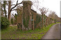
2
New Kennacott
Taken from the same spot as Image, looking across the valley to the south of Newton Tracey to buildings at Kennacott. New Kennacott is directly behind the pylon; the house at West Kennacott, to its left, straddles with gridline into SS5326.
Image: © Derek Harper
Taken: 30 Oct 2007
0.20 miles
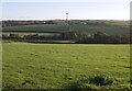
3
Rough grassland, Newton Tracey
Looking up from the footpath beside Langham Lake below Kennacott.
Image: © Andrew Smith
Taken: 7 Sep 2008
0.20 miles
4
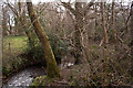
A stream near Newton Tracey which leads to Langham Lake
Image: © Roger A Smith
Taken: 16 Apr 2013
0.23 miles
5
A road which leads away from the Kennacotts to Bartridge Hill
Image: © Roger A Smith
Taken: 16 Apr 2013
0.25 miles