IMAGES TAKEN NEAR TO
Newton Tracey, BARNSTAPLE, EX31 3PP
Introduction
This page details the photographs taken nearby to EX31 3PP by members of the Geograph project.
The Geograph project started in 2005 with the aim of publishing, organising and preserving representative images for every square kilometre of Great Britain, Ireland and the Isle of Man.

There are currently over 7.5m images from over14,400 individuals and you can help contribute to the project by visiting https://www.geograph.org.uk
Image Map (Loading...)


Getting Data...Please wait
Leaflet Map data © OpenStreetMap
Images are licensed for reuse under creativecommons.org/licenses/by-sa/2.0
Notes
- Clicking on the map will re-center to the selected point.
- The higher the marker number, the further away the image location is from the centre of the postcode.
Image Listing (12 Images Found)
Images are licensed for reuse under creativecommons.org/licenses/by-sa/2.0
Image
Details
Distance
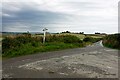
2
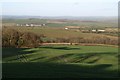
East Woodlands from Luppincott
A view almost from one corner of the square to the opposite corner. The square contains three valleys forming an amphitheatre, which meet this side of East Woodlands (on the right). The prominent white house in the centre is just across a gridline into SS5325. Beyond, the countryside rolls away to the Taw valley and the western foothills of Exmoor. Taken from a gateway just to the north of the farm at Luppincott.
Image: © Derek Harper
Taken: 24 Jan 2008
0.08 miles
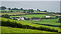
6
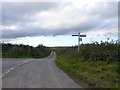
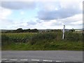
Woodland Cross
A leaning signpost at the slightly offset lane crossroads. Image was taken from a gateway a metre or two to the left.
Image: © Derek Harper
Taken: 24 Jan 2008
0.11 miles
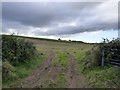
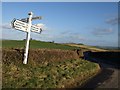
9
Maize at Woodland Cross
One arm of the signpost has vanished
Image: © David Smith
Taken: 8 Oct 2015
0.12 miles
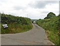
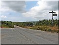
10
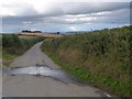
The road to Glass Water Bridge
A narrow road between banks and hedgebanks
Image: © David Smith
Taken: 8 Oct 2015
0.13 miles