IMAGES TAKEN NEAR TO
Yarnscombe, BARNSTAPLE, EX31 3LY
Introduction
This page details the photographs taken nearby to EX31 3LY by members of the Geograph project.
The Geograph project started in 2005 with the aim of publishing, organising and preserving representative images for every square kilometre of Great Britain, Ireland and the Isle of Man.

There are currently over 7.5m images from over14,400 individuals and you can help contribute to the project by visiting https://www.geograph.org.uk
Image Map (Loading...)


Getting Data...Please wait
Leaflet Map data © OpenStreetMap
Images are licensed for reuse under creativecommons.org/licenses/by-sa/2.0
Notes
- Clicking on the map will re-center to the selected point.
- The higher the marker number, the further away the image location is from the centre of the postcode.
Image Listing (12 Images Found)
Images are licensed for reuse under creativecommons.org/licenses/by-sa/2.0
Image
Details
Distance
1
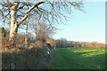
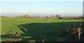
Field by Southdown Plantation
Southdown Plantation is the wood at the far side. This view was taken just across the lane from Image
Image: © Derek Harper
Taken: 30 Nov 2016
0.05 miles
2
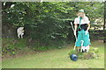
Torridge : Little Bo Peep & Verge
On the verge of the road near Crossbury is this Little Bo Peep scarecrow.
Image: © Lewis Clarke
Taken: 9 Aug 2014
0.07 miles
3
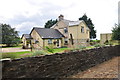
Torridge : Crossbury
Looking towards Crossbury which is a house near Cloggshill Cross.
Image: © Lewis Clarke
Taken: 9 Aug 2014
0.08 miles
4
Entrance to paintball games
A wood where you can play with paintballs and laser "guns"
Image: © David Smith
Taken: 26 Apr 2013
0.09 miles
5

Private driveway, near Cloggshill Cross
Image: © Roger Cornfoot
Taken: 22 Feb 2021
0.09 miles
6
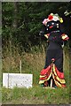
Torridge : Scarecrow
A scarecrow outside the village of Yarcombe which is part of a small competition the village were holding.
Image: © Lewis Clarke
Taken: 9 Aug 2014
0.10 miles
7

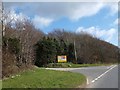
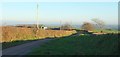
Autumn colour at Cloggshill Cross
On the right is Southdown Plantation; the verge is wide to give sightlines along the main road
Image: © David Smith
Taken: 8 Oct 2015
0.10 miles
8

Cloggshill Cross
The road on the left marks the southern edge of a patch of woodland, part of which is used for paintballing
Image: © David Smith
Taken: 26 Apr 2013
0.11 miles
9
Field on Easton Moor
Looking right from the same gateway as Image On the extreme right is part of the farm shown in Image
Image: © Derek Harper
Taken: 30 Nov 2016
0.12 miles
10
Lane on Easton Moor
Passing Easton Moor the farm as it heads across Easton Moor, the area of countryside.
Image: © Derek Harper
Taken: 30 Nov 2016
0.12 miles