IMAGES TAKEN NEAR TO
Tawstock, BARNSTAPLE, EX31 3JX
Introduction
This page details the photographs taken nearby to EX31 3JX by members of the Geograph project.
The Geograph project started in 2005 with the aim of publishing, organising and preserving representative images for every square kilometre of Great Britain, Ireland and the Isle of Man.

There are currently over 7.5m images from over14,400 individuals and you can help contribute to the project by visiting https://www.geograph.org.uk
Image Map
Images are licensed for reuse under creativecommons.org/licenses/by-sa/2.0
Notes
- Clicking on the map will re-center to the selected point.
- The higher the marker number, the further away the image location is from the centre of the postcode.
Image Listing (17 Images Found)
Images are licensed for reuse under creativecommons.org/licenses/by-sa/2.0
Image
Details
Distance
1
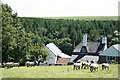
Tawstock: overlooking Sideham
Farmhouse in remote country
Image: © Martin Bodman
Taken: 7 Jul 2007
0.01 miles
3
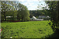
Sideham
The farm seen from where Image] was taken, looking left.
Image: © Derek Harper
Taken: 4 May 2019
0.01 miles

5
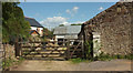
Sideham
A farm down a very minor lane; if you're planning a vehicular visit, the northern route is recommended over the southern.
Image: © Derek Harper
Taken: 4 May 2019
0.01 miles
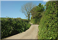
6
Tawstock: lane to Sideham
Looking west-south-west
Image: © Martin Bodman
Taken: 7 Jul 2007
0.02 miles
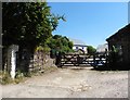
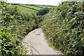
7
Lane at Sideham
Looking left from where Image] was taken. This is the more motor-worthy road, passing the entrance to the farm Image
Image: © Derek Harper
Taken: 4 May 2019
0.02 miles
8

Lane near Sideham
The northern lane to the farm approaches it.
Image: © Derek Harper
Taken: 4 May 2019
0.03 miles
9

Lane at Sideham
The southern arm of the lane past the farm sets off for the outside world. You will perhaps get some idea of why I recommend the northern arm to reach the farm if in a vehicle.
Image: © Derek Harper
Taken: 4 May 2019
0.04 miles
10
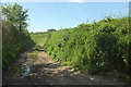
Green Lane, Sideham
A route with public access that soon splits in two, taking you to either Pristacott or Newton Cross.
Image: © Derek Harper
Taken: 4 May 2019
0.06 miles