IMAGES TAKEN NEAR TO
Fremington, BARNSTAPLE, EX31 3DQ
Introduction
This page details the photographs taken nearby to EX31 3DQ by members of the Geograph project.
The Geograph project started in 2005 with the aim of publishing, organising and preserving representative images for every square kilometre of Great Britain, Ireland and the Isle of Man.

There are currently over 7.5m images from over14,400 individuals and you can help contribute to the project by visiting https://www.geograph.org.uk
Image Map (Loading...)


Getting Data...Please wait
Leaflet Map data © OpenStreetMap
Images are licensed for reuse under creativecommons.org/licenses/by-sa/2.0
Notes
- Clicking on the map will re-center to the selected point.
- The higher the marker number, the further away the image location is from the centre of the postcode.
Image Listing (176 Images Found)
Images are licensed for reuse under creativecommons.org/licenses/by-sa/2.0
Image
Details
Distance
1
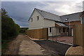
Fremington : Small Track
A track heading out of Fremington and beside a house.
Image: © Lewis Clarke
Taken: 27 Apr 2014
0.03 miles
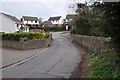
2
Fremington : Mill Road
Looking down Mill Road with houses alongside it.
Image: © Lewis Clarke
Taken: 27 Apr 2014
0.05 miles
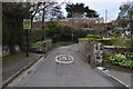
4

Fremington Parish Council's Beechfield Centre
Image: © Roger A Smith
Taken: 7 Apr 2020
0.06 miles

6
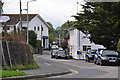
Fremington : Higher Road
Looking along Higher Road in Fremington.
Image: © Lewis Clarke
Taken: 27 Apr 2014
0.07 miles
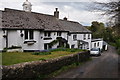
7
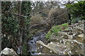
Looking upstream from a bridge on Mill Road
Image: © Roger A Smith
Taken: 22 Mar 2011
0.07 miles

10
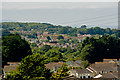
The centre of this image is around 26 Higher Road, Fremington
The houses in the foreground are in Bickington.
Image: © Roger A Smith
Taken: 28 Aug 2017
0.08 miles