IMAGES TAKEN NEAR TO
Heal Park Crescent, BARNSTAPLE, EX31 3AP
Introduction
This page details the photographs taken nearby to Heal Park Crescent, EX31 3AP by members of the Geograph project.
The Geograph project started in 2005 with the aim of publishing, organising and preserving representative images for every square kilometre of Great Britain, Ireland and the Isle of Man.

There are currently over 7.5m images from over14,400 individuals and you can help contribute to the project by visiting https://www.geograph.org.uk
Image Map
Images are licensed for reuse under creativecommons.org/licenses/by-sa/2.0
Notes
- Clicking on the map will re-center to the selected point.
- The higher the marker number, the further away the image location is from the centre of the postcode.
Image Listing (79 Images Found)
Images are licensed for reuse under creativecommons.org/licenses/by-sa/2.0
Image
Details
Distance
1

A path through Sampson's Plantation approaching properties in Blakeland Road
The map refers to this wood as Sampson's Plantation. A new housing development built on the site of a breakers yard to the west of the wood is also known by the same name.
Image: © Roger A Smith
Taken: 9 Apr 2011
0.09 miles
2
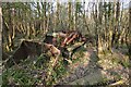
Abandoned machinery in Sampson's Plantation
The map refers to this wood as Sampson's Plantation. A new housing development built on the site of a breakers yard to the west of the wood is also known by the same name.
Image: © Roger A Smith
Taken: 9 Apr 2011
0.11 miles
3
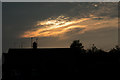
The rising sun illuminates cloud formations over Fremington
Image: © Roger A Smith
Taken: 10 May 2020
0.11 miles
4
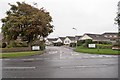
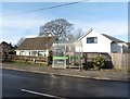
Beechfield Road at the junction with Yelland Road
Image: © Roger A Smith
Taken: 25 Sep 2011
0.11 miles
5
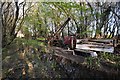
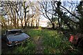
Abandoned vehicle beside groundwater in Sampson's Plantation
The map refers to this wood as Sampson's Plantation. A new housing development built on the site of a breakers yard to the west of the wood is also known by the same name.
Image: © Roger A Smith
Taken: 9 Apr 2011
0.12 miles
6

Re-surfacing work on the B3233 at Fremington
Image: © Roger A Smith
Taken: 10 Apr 2015
0.13 miles
7

Yelland Road at the junction with Chilpark and Beechfield Road
Image: © Roger A Smith
Taken: 25 Sep 2011
0.13 miles
9

Abandoned machinery in Sampson's Plantation
Image: © Roger A Smith
Taken: 9 Apr 2011
0.13 miles
10
An abandoned vehicle in woods known as Sampson's Plantation
The North East corner of a new housing development, also know as Sampson's Plantation, can be seen through the trees.
Image: © Roger A Smith
Taken: 9 Apr 2011
0.13 miles