IMAGES TAKEN NEAR TO
Coppice Close, BARNSTAPLE, EX31 2QE
Introduction
This page details the photographs taken nearby to Coppice Close, EX31 2QE by members of the Geograph project.
The Geograph project started in 2005 with the aim of publishing, organising and preserving representative images for every square kilometre of Great Britain, Ireland and the Isle of Man.

There are currently over 7.5m images from over14,400 individuals and you can help contribute to the project by visiting https://www.geograph.org.uk
Image Map
Images are licensed for reuse under creativecommons.org/licenses/by-sa/2.0
Notes
- Clicking on the map will re-center to the selected point.
- The higher the marker number, the further away the image location is from the centre of the postcode.
Image Listing (217 Images Found)
Images are licensed for reuse under creativecommons.org/licenses/by-sa/2.0
Image
Details
Distance
1
3 Miles to Barum on the B3233 from Fremington
Barum is an historic name for Barnstaple.
Image: © Roger A Smith
Taken: 1 Apr 2012
0.04 miles

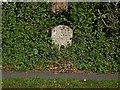
3

Old Milestone by the B3233, Fremington
Carved stone post by the B3233, in parish of FREMINGTON (NORTH DEVON District), village, 80m East of Red Lane, by Vicarage, opposite Broady Strap, under hedge, on verge behind path, on North side of road. Barum tombstone, erected by the Barnstaple turnpike trust in the 19th century.
Inscription reads:-
3
BARUM
Milestone Society National ID: DV_BSBF03
Image: © Alan Rosevear
Taken: 8 Feb 2013
0.05 miles
4
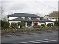
Han Court Chinese Restaurant, Fremington
Image: © Roger Cornfoot
Taken: 22 Nov 2014
0.08 miles
5
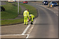
White line marking a junction with the B3233
Image: © Roger A Smith
Taken: 22 Feb 2018
0.08 miles
6
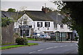
Fremington : Mill Hill B3233
Looking along Mill Hill and Beauty Lines nail bar in view.
Image: © Lewis Clarke
Taken: 27 Apr 2014
0.09 miles
7
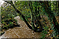
An un-named stream which leads to Fremington Pill
One of many waterways which emanate from nearby hills.
Image: © Roger A Smith
Taken: 31 Oct 2020
0.09 miles
8

Fremington : Redlands Road
From Mill Hill looking towards Redlands Road and houses alongside it.
Image: © Lewis Clarke
Taken: 27 Apr 2014
0.09 miles
9
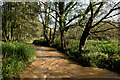
An un-named stream heading towards Fremington Pill
Image: © Roger A Smith
Taken: 31 Oct 2020
0.09 miles
10
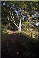
The footpath from Fremington to the quay
Image: © Roger A Smith
Taken: 27 Oct 2010
0.09 miles