IMAGES TAKEN NEAR TO
Mead Park, BARNSTAPLE, EX31 2PF
Introduction
This page details the photographs taken nearby to Mead Park, EX31 2PF by members of the Geograph project.
The Geograph project started in 2005 with the aim of publishing, organising and preserving representative images for every square kilometre of Great Britain, Ireland and the Isle of Man.

There are currently over 7.5m images from over14,400 individuals and you can help contribute to the project by visiting https://www.geograph.org.uk
Image Map (Loading...)


Getting Data...Please wait
Leaflet Map data © OpenStreetMap
Images are licensed for reuse under creativecommons.org/licenses/by-sa/2.0
Notes
- Clicking on the map will re-center to the selected point.
- The higher the marker number, the further away the image location is from the centre of the postcode.
Image Listing (107 Images Found)
Images are licensed for reuse under creativecommons.org/licenses/by-sa/2.0
Image
Details
Distance
1
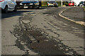
A structural failure in the road surface on Mead Park
Image: © Roger A Smith
Taken: 27 Mar 2023
0.04 miles
2

A structural failure in the road surface on Mead Park
Image: © Roger A Smith
Taken: 27 Mar 2023
0.04 miles
3
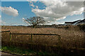
An overgrown plot of land behind bungalows on Mead Park
Image: © Roger A Smith
Taken: 26 Feb 2023
0.06 miles
4
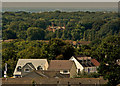
The old and the new in Fremington and Bickington
Fremington Manor in the distance was built between 1708 & 1713. The estate in the foreground was built between 2017 & 2020.
Image: © Roger A Smith
Taken: 28 Aug 2017
0.06 miles
5
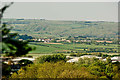
A housing development on Mead Park
See also: Image
The farm buildings on the horizon are at a property known as Kari Koa, outside Fremington.
The roof tops in the foreground are on the Pottington Industrial Estate.
Image: © Roger A Smith
Taken: 5 May 2017
0.07 miles
6
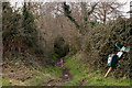
A footpath heading west towards Penhill and Muddlebridge
See also: Image
Image: © Roger A Smith
Taken: 10 Feb 2017
0.07 miles
7
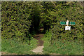
A footpath at Mead Park heading west towards Penhill and Muddlebridge
See also: Image
Image: © Roger A Smith
Taken: 14 Apr 2021
0.07 miles
8
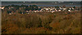
Mead Park, Bickington and surrounds
Mead Park is in the centre of this image. The river is the Taw.
Image: © Roger A Smith
Taken: 5 Dec 2022
0.08 miles
9
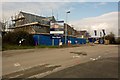
A new housing development at Mead Park, Bickington
Image: © Roger A Smith
Taken: 10 Feb 2017
0.08 miles
10
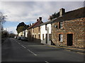
Terraced cottages on Bickington Road
Image: © Roger Cornfoot
Taken: 22 Nov 2014
0.08 miles