IMAGES TAKEN NEAR TO
Crescent Avenue, BARNSTAPLE, EX31 2ED
Introduction
This page details the photographs taken nearby to Crescent Avenue, EX31 2ED by members of the Geograph project.
The Geograph project started in 2005 with the aim of publishing, organising and preserving representative images for every square kilometre of Great Britain, Ireland and the Isle of Man.

There are currently over 7.5m images from over14,400 individuals and you can help contribute to the project by visiting https://www.geograph.org.uk
Image Map
Images are licensed for reuse under creativecommons.org/licenses/by-sa/2.0
Notes
- Clicking on the map will re-center to the selected point.
- The higher the marker number, the further away the image location is from the centre of the postcode.
Image Listing (93 Images Found)
Images are licensed for reuse under creativecommons.org/licenses/by-sa/2.0
Image
Details
Distance
1

Laundrette Revolution at Sticklepath Service Station
https://www.revolution-laundry.com
Image: © Roger A Smith
Taken: 8 Mar 2022
0.03 miles

3
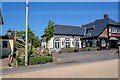
Barnstaple : Bickington Road
Looking towards the Wrey Arms on Bickington Road.
Image: © Lewis Clarke
Taken: 27 May 2020
0.04 miles
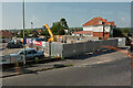
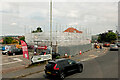
7
Work progressing on Windy Ridge, Sticklepath
Image: © Roger A Smith
Taken: 17 Jun 2023
0.04 miles
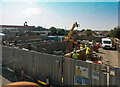
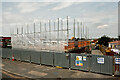
8
Windy Ridge behind a screen of plastic sheet
Image: © Roger A Smith
Taken: 17 Jun 2023
0.04 miles
9
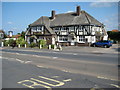
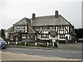
Wrey Arms, Sticklepath
The Wrey Arms is on the A3125 at Sticklepath near Barnstaple.
Image: © Philip Halling
Taken: 11 Jun 2009
0.04 miles
10
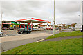
A hand car wash and a filling station on the A3125 at Sticklepath
Image: © Roger A Smith
Taken: 10 Mar 2018
0.04 miles