IMAGES TAKEN NEAR TO
Cleave Close, BARNSTAPLE, EX31 2DX
Introduction
This page details the photographs taken nearby to Cleave Close, EX31 2DX by members of the Geograph project.
The Geograph project started in 2005 with the aim of publishing, organising and preserving representative images for every square kilometre of Great Britain, Ireland and the Isle of Man.

There are currently over 7.5m images from over14,400 individuals and you can help contribute to the project by visiting https://www.geograph.org.uk
Image Map (Loading...)


Getting Data...Please wait
Leaflet Map data © OpenStreetMap
Images are licensed for reuse under creativecommons.org/licenses/by-sa/2.0
Notes
- Clicking on the map will re-center to the selected point.
- The higher the marker number, the further away the image location is from the centre of the postcode.
Image Listing (91 Images Found)
Images are licensed for reuse under creativecommons.org/licenses/by-sa/2.0
Image
Details
Distance
1
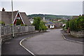
Sticklepath : Cleave Road
Looking down the road which heads to the houses.
Image: © Lewis Clarke
Taken: 27 Apr 2014
0.04 miles
2
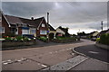
Sticklepath : Beechwood Avenue
From the junction with Cleave Road looking along Beechwood Avenue.
Image: © Lewis Clarke
Taken: 27 Apr 2014
0.04 miles
3
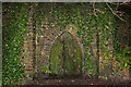
A 19th Century folly at Dripping Well in Anchor Wood
This is the site of an ancient holy well.
Image: © Roger A Smith
Taken: 30 Dec 2017
0.06 miles
4
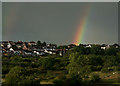
A rainbow descends upon Oaklands Residential Care Home
The properties to the left are those on Cleave Close and neighbouring streets.
Image: © Roger A Smith
Taken: 2 Sep 2019
0.06 miles
5
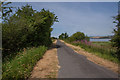
Tarka Trail
Heading towards Instow, this part of the trail has long straight stretches.
Image: © Guy Wareham
Taken: 8 Jul 2019
0.10 miles
6
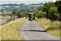
A one mile straight section of the Tarka Trail approaching Barnstaple
Image: © Roger A Smith
Taken: 11 Jul 2011
0.10 miles
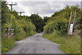
7
North Devon : The Tarka Trail
The Tarka Trail heading into the urban areas surrounding Barnstaple.
Image: © Lewis Clarke
Taken: 27 Apr 2014
0.10 miles
8
The Tarka Trail to Barnstaple branches right to pass through Anchor Wood
Image: © Roger A Smith
Taken: 24 Jun 2011
0.11 miles
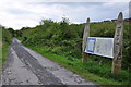
9
A footpath leading off from the Tarka Trail which leads to and circumnavigates Anchorwood Bank
The footpath has been recently resurfaced.
Image: © Roger A Smith
Taken: 29 Jun 2021
0.11 miles
10

Sticklepath : Cleave Road
Cleave Road heading through the residential areas of Sticklepath.
Image: © Lewis Clarke
Taken: 27 Apr 2014
0.11 miles