IMAGES TAKEN NEAR TO
Cleave Road, BARNSTAPLE, EX31 2AT
Introduction
This page details the photographs taken nearby to Cleave Road, EX31 2AT by members of the Geograph project.
The Geograph project started in 2005 with the aim of publishing, organising and preserving representative images for every square kilometre of Great Britain, Ireland and the Isle of Man.

There are currently over 7.5m images from over14,400 individuals and you can help contribute to the project by visiting https://www.geograph.org.uk
Image Map
Images are licensed for reuse under creativecommons.org/licenses/by-sa/2.0
Notes
- Clicking on the map will re-center to the selected point.
- The higher the marker number, the further away the image location is from the centre of the postcode.
Image Listing (250 Images Found)
Images are licensed for reuse under creativecommons.org/licenses/by-sa/2.0
Image
Details
Distance
1
Sticklepath : Cleave Road
A footpath and road heading into Sticklepath.
Image: © Lewis Clarke
Taken: 27 Apr 2014
0.02 miles
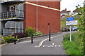
2
Barnstaple : Cleave Road
Looking along Cleave Road.
Image: © Lewis Clarke
Taken: 5 May 2019
0.03 miles
3

Sticklepath Hill in 2005 before construction of the new A3125
See also: Image
Image: © Peter Hern
Taken: 6 Feb 2005
0.03 miles
4
Sticklepath Hill in 2013 after construction of the new A3125
See also: Image
Image: © Roger A Smith
Taken: 13 Jun 2013
0.03 miles
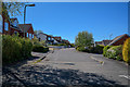
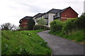
5
Sticklepath : Cleave Road
Looking along a small residential road in Sticklepath.
Image: © Lewis Clarke
Taken: 27 Apr 2014
0.03 miles
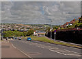
6
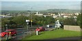
A3125 on Sticklepath Hill
A recent stretch of main road leading to Sticklepath Junction to give access to the Taw Bridge, visible on the extreme left, and seen from the former line of the main road. A good view of the town and river.
Image: © Derek Harper
Taken: 27 Sep 2016
0.04 miles
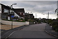
7
Sticklepath : Footpath
A footpath from the Tarka Trail to Cleave Road.
Image: © Lewis Clarke
Taken: 27 Apr 2014
0.04 miles
8

Sticklepath Hill in 2006 during construction of the new A3125
See also: Image
Image: © Peter Hern
Taken: 9 Mar 2006
0.04 miles
9

Sticklepath Hill in 2016, 10 years after completion of the new A3125
See also: Image
Image: © Roger A Smith
Taken: 20 Jan 2016
0.04 miles
10
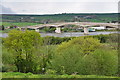
Sticklepath : Treetops & River Taw
Looking across the treetops and towards the River Taw and bridge across it.
Image: © Lewis Clarke
Taken: 27 Apr 2014
0.04 miles