IMAGES TAKEN NEAR TO
Nursery End, BARNSTAPLE, EX31 1RA
Introduction
This page details the photographs taken nearby to Nursery End, EX31 1RA by members of the Geograph project.
The Geograph project started in 2005 with the aim of publishing, organising and preserving representative images for every square kilometre of Great Britain, Ireland and the Isle of Man.

There are currently over 7.5m images from over14,400 individuals and you can help contribute to the project by visiting https://www.geograph.org.uk
Image Map (Loading...)


Getting Data...Please wait
Leaflet Map data © OpenStreetMap
Images are licensed for reuse under creativecommons.org/licenses/by-sa/2.0
Notes
- Clicking on the map will re-center to the selected point.
- The higher the marker number, the further away the image location is from the centre of the postcode.
Image Listing (158 Images Found)
Images are licensed for reuse under creativecommons.org/licenses/by-sa/2.0
Image
Details
Distance
1

St Mary's church, Pilton - monument to Christopher Lethbridge
A flamboyant wall monument to Christopher Lethbridge (†1713).
Image: © Mike Searle
Taken: 5 Jun 2013
0.03 miles
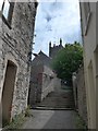
3

Path running parallel with the churchyard
Image: © Basher Eyre
Taken: 26 May 2015
0.03 miles
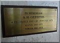
4

St Mary, Pilton: Those Who Served (1914-1918)
Image: © Basher Eyre
Taken: 26 May 2015
0.03 miles

8

St Mary's church, Pilton - monument to Sir Robert Chichester (detail 2)
Image: © Mike Searle
Taken: 5 Jun 2013
0.03 miles