IMAGES TAKEN NEAR TO
Lynbro Road, BARNSTAPLE, EX31 1QG
Introduction
This page details the photographs taken nearby to Lynbro Road, EX31 1QG by members of the Geograph project.
The Geograph project started in 2005 with the aim of publishing, organising and preserving representative images for every square kilometre of Great Britain, Ireland and the Isle of Man.

There are currently over 7.5m images from over14,400 individuals and you can help contribute to the project by visiting https://www.geograph.org.uk
Image Map (Loading...)


Getting Data...Please wait
Leaflet Map data © OpenStreetMap
Images are licensed for reuse under creativecommons.org/licenses/by-sa/2.0
Notes
- Clicking on the map will re-center to the selected point.
- The higher the marker number, the further away the image location is from the centre of the postcode.
Image Listing (143 Images Found)
Images are licensed for reuse under creativecommons.org/licenses/by-sa/2.0
Image
Details
Distance
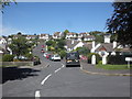
2

Looking across the north eastern suburbs of Barnstaple and some of Pilton
The house on the horizon to the left of centre is Upcott House. Pilton Church is in the far left whilst the North Devon District hospital is to the far right. The houses in the foreground are on Silverwood Heights.
Image: © Roger A Smith
Taken: 17 May 2023
0.13 miles
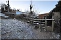
5
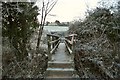
A footbridge over Bradiford Water near Anchor Mill
Image: © Roger A Smith
Taken: 21 Jan 2011
0.16 miles
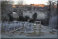
6
A footbridge over Bradiford Water near Anchor Mill
Image: © Roger A Smith
Taken: 21 Jan 2011
0.16 miles
7
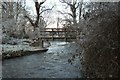
A footbridge over Bradiford Water near Anchor Mill as seen from downstream
Image: © Roger A Smith
Taken: 21 Jan 2011
0.16 miles
8
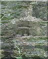
Ordnance Survey Cut Mark
This OS cut mark can be found on the NW side of Mear Top. It marks a point 45.741m above mean sea level.
Image: © Adrian Dust
Taken: 8 Jul 2016
0.17 miles
9

Ordnance Survey Cut Mark
This OS cut mark can be found on the SE side of Mear Top. It marks a point 38.094m above mean sea level.
Image: © Adrian Dust
Taken: 8 Jul 2016
0.17 miles
10

Ordnance Survey Cut Mark
This OS cut mark can be found on the south side of Dark Lane. It marks a point 22.802m above mean sea level.
Image: © Adrian Dust
Taken: 8 Jul 2016
0.18 miles