IMAGES TAKEN NEAR TO
Church Lane, BARNSTAPLE, EX31 1EH
Introduction
This page details the photographs taken nearby to Church Lane, EX31 1EH by members of the Geograph project.
The Geograph project started in 2005 with the aim of publishing, organising and preserving representative images for every square kilometre of Great Britain, Ireland and the Isle of Man.

There are currently over 7.5m images from over14,400 individuals and you can help contribute to the project by visiting https://www.geograph.org.uk
Image Map
Images are licensed for reuse under creativecommons.org/licenses/by-sa/2.0
Notes
- Clicking on the map will re-center to the selected point.
- The higher the marker number, the further away the image location is from the centre of the postcode.
Image Listing (1317 Images Found)
Images are licensed for reuse under creativecommons.org/licenses/by-sa/2.0
Image
Details
Distance
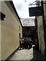
1
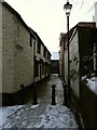
Church Lane leading away from Paternoster Row
Image: © Roger A Smith
Taken: 6 Jan 2010
0.00 miles
2
Church Lane leading to Paternoster Row
Image: © Roger A Smith
Taken: 6 Jan 2010
0.00 miles
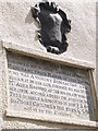
4
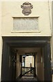
Entrance to Horwood's Almshouses, Barnstaple
The pump visible in the courtyard is listed and described at https://www.historicengland.org.uk/listing/the-list/list-entry/1385103 . The almshouses are grade II* listed. The plaque above the entrance reads "This Alms Hous was founded & endowed by y worll Thomas Horwood merchant twice mayor of this towne who was a worthy benefactor and began it in his life, finished by his wife Mrs Alice Horwood after his death who of her owne accord added the adioying free school and endowed it for 20 poore children forever 1659 abi et tu fac similiter" https://www.historicengland.org.uk/listing/the-list/list-entry/1385102 .
Image: © Derek Harper
Taken: 27 Sep 2016
0.01 miles
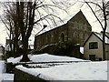
5
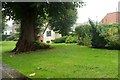
By Paternoster Row, Barnstaple
An early autumn view compared to the very wintry scene in Image, taken past the tree. Immediately to the right of the trunk is the end of the row of the grade II* listed Paige's Almshouses https://www.historicengland.org.uk/listing/the-list/list-entry/1385106 . Behind the tree is the Parish hall (shown more clearly in Image), also listed https://www.historicengland.org.uk/listing/the-list/list-entry/1385252 ; architect WC Oliver.
Image: © Derek Harper
Taken: 27 Sep 2016
0.01 miles
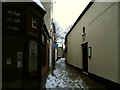
7
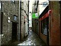
Church Lane leading to the High Street
Image: © Roger A Smith
Taken: 6 Jan 2010
0.01 miles
9
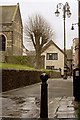
Barnstaple : Footpath
A footpath heads towards the town centre and beside St Peter's Church.
Image: © Lewis Clarke
Taken: 5 Jan 2021
0.02 miles
10
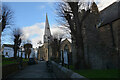
Looking down Church Lane, Barnstaple
St. Anne's Chapel is to the left.
Image: © Roger A Smith
Taken: 1 May 2016
0.02 miles