IMAGES TAKEN NEAR TO
Clyst St. George, EXETER, EX3 0RE
Introduction
This page details the photographs taken nearby to EX3 0RE by members of the Geograph project.
The Geograph project started in 2005 with the aim of publishing, organising and preserving representative images for every square kilometre of Great Britain, Ireland and the Isle of Man.

There are currently over 7.5m images from over14,400 individuals and you can help contribute to the project by visiting https://www.geograph.org.uk
Image Map
Images are licensed for reuse under creativecommons.org/licenses/by-sa/2.0
Notes
- Clicking on the map will re-center to the selected point.
- The higher the marker number, the further away the image location is from the centre of the postcode.
Image Listing (59 Images Found)
Images are licensed for reuse under creativecommons.org/licenses/by-sa/2.0
Image
Details
Distance
1
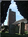
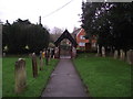
Clyst St George church
The tower is framed by yew trees that surround the churchyard.
Image: © David Smith
Taken: 9 Apr 2010
0.04 miles
2
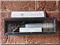
A bomb in the church at Clyst St George
Mounted on the wall in the porch of the Clyst St George parish church http://www.geograph.org.uk/photo/1309379 .
The notice above the bomb states:
"An Incendiary Bomb
Scores of these were dropped on Clyst St George on the night of August 31st 1940 destroying
several houses in the village and the rectory stables. One dropped inside the church organ
setting fire to the church that, as the photos (inside church) show, was completely burnt out."
[Apologies for the reflection]
Image: © Robin Drayton
Taken: 9 May 2009
0.04 miles

4
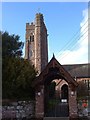
Parish Church, Clyst St George
"The body of the church almost entirely rebuilt by Rev H T Ellacombe in 1854-5, and this in turn was reduced to ruins by an incendiary bomb in 1940; the post-war rebuilding (which was not a copy of Ellacombe's work) was completed in 1952" http://www.historicengland.org.uk/listing/the-list/list-entry/1164124 . "The tower has the slim profile characteristic of many churches in the Exeter area." In the foreground is the lych gate (1867), also listed together with the churchyard wall http://www.historicengland.org.uk/listing/the-list/list-entry/1317900 . See also Image
Image: © Derek Harper
Taken: 27 Mar 2006
0.04 miles

6
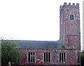
Parish Church, Clyst St George
The church from the north side of the churchyard; for views from the other side, see Image] and Image http://www.historicengland.org.uk/listing/the-list/list-entry/1164124 .
Image: © Derek Harper
Taken: 27 Mar 2006
0.04 miles
7
Don't be naughty or else
Stocks at Clyst St George church.
Image: © Anthony Vosper
Taken: 8 Jan 2016
0.04 miles
8
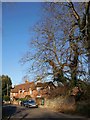
Cottage at Clyst St George
This large brick cottage is opposite the school on Woodbury Road, formerly the through road from Exeter to Woodbury.
Image: © Derek Harper
Taken: 4 Jan 2010
0.05 miles
9
Looking South
Clyst St George church lych gate. Viewed from the church.
Image: © Anthony Vosper
Taken: 8 Jan 2016
0.05 miles
10
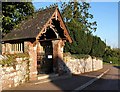
Lychgate, Clyst St George
This view of Image shows the six miniature mullion openings on each lateral wall. The lychgate http://www.imagesofengland.org.uk/Details/Default.aspx?id=86146&mode=adv was designed in 1867 by the Rev Henry Thomas Ellacombe, rector here from 1850-1880. His "The history and antiquities of the parish of Clyst St. George" can be read here http://books.google.co.uk/books?id=ERUWAAAAYAAJ&dq=Ellacombe+Clyst+St+George&printsec=frontcover&source=bl&ots=eJkCgfi0Fo&sig=xjOyebwNuJNSF7Dyd6O7-j91kZ4&hl=en&ei=HoVMS4fWOuKNjAeVoPG4DQ&sa=X&oi=book_result&ct=result&resnum=1&ved=0CAkQ6AEwAA#v=onepage&q=&f=false . For another view of the wrought iron gates, see Image
Image: © Derek Harper
Taken: 4 Jan 2010
0.05 miles