IMAGES TAKEN NEAR TO
Ferry Road, EXETER, EX3 0JH
Introduction
This page details the photographs taken nearby to Ferry Road, EX3 0JH by members of the Geograph project.
The Geograph project started in 2005 with the aim of publishing, organising and preserving representative images for every square kilometre of Great Britain, Ireland and the Isle of Man.

There are currently over 7.5m images from over14,400 individuals and you can help contribute to the project by visiting https://www.geograph.org.uk
Image Map
Images are licensed for reuse under creativecommons.org/licenses/by-sa/2.0
Notes
- Clicking on the map will re-center to the selected point.
- The higher the marker number, the further away the image location is from the centre of the postcode.
Image Listing (700 Images Found)
Images are licensed for reuse under creativecommons.org/licenses/by-sa/2.0
Image
Details
Distance

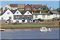
3

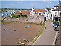
The Passage House Inn, Topsham
Reputedly the oldest surviving pub in Topsham.
Image: © N Chadwick
Taken: 28 Dec 2008
0.01 miles
4
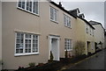
Passage House
Grade II listed. http://www.britishlistedbuildings.co.uk/en-89066-14-ferry-road-devon
Image: © N Chadwick
Taken: 31 Dec 2012
0.02 miles
5

Wixels, Ferry Rd
Grade II listed. http://www.britishlistedbuildings.co.uk/en-89076-wixels-devon
Image: © N Chadwick
Taken: 31 Dec 2012
0.02 miles
6
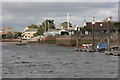
Topsham waterfront
The building with a red tiled roof and white Dutch style gables is called Wixells, and is in The Strand. Some of the many boatyard pontoons in this part of Topsham can be seen. taken from on board the MV My Queen on an RSPB organised cruise.
Image: © Adrian Platt
Taken: 22 Feb 2009
0.02 miles
7
House in Ferry Road, Topsham
The house has a pair of finely decorated chimney-pots. In the foreground are mudflats exposed by low water in the (tidal) River Exe
Image: © David Smith
Taken: 8 Aug 2010
0.02 miles
8

Ferry Road, Topsham
Now closed to through traffic with more than two wheels.
Image: © Richard Webb
Taken: 19 Apr 2011
0.02 miles
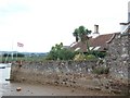
9
Wixels, Topsham, from beside the church
Wixels was originally a sail loft. The dutch gables seem to be a fairly recent addition. View with the River Exe, looking upstream, and the M5 viaduct in the distance.
Image: © Derek Harper
Taken: 2 Jun 2006
0.02 miles
10
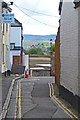
Exe Street, Topsham
This narrow lane leads from Fore Street to the banks of the Exe estuary.
The land in the distance is on the west side of the estuary.
Image: © mike smith
Taken: 15 Apr 2012
0.03 miles