IMAGES TAKEN NEAR TO
Marine Drive, EX3 0FU
Introduction
This page details the photographs taken nearby to Marine Drive, EX3 0FU by members of the Geograph project.
The Geograph project started in 2005 with the aim of publishing, organising and preserving representative images for every square kilometre of Great Britain, Ireland and the Isle of Man.

There are currently over 7.5m images from over14,400 individuals and you can help contribute to the project by visiting https://www.geograph.org.uk
Image Map
Images are licensed for reuse under creativecommons.org/licenses/by-sa/2.0
Notes
- Clicking on the map will re-center to the selected point.
- The higher the marker number, the further away the image location is from the centre of the postcode.
Image Listing (23 Images Found)
Images are licensed for reuse under creativecommons.org/licenses/by-sa/2.0
Image
Details
Distance
1
Topsham : Clyst Road
Clyst Road heading out of the town of Topsham.
Image: © Lewis Clarke
Taken: 5 Nov 2013
0.08 miles
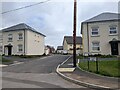
2
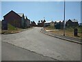
Artillery Avenue, Topsham
A small housing estate on the edge of Topsham
Image: © David Smith
Taken: 14 Jun 2023
0.08 miles
3

Fake frontage of small apartment block, Carrick Mill, Topsham
Under the bricked window, the door is a fake (the plants in front give it away). This is a small block of affordable homes in an estate developed 2023-2024
Image: © David Smith
Taken: 4 May 2024
0.09 miles
5

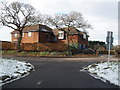
Housing estate, Artillery Avenue, Topsham
Image: © David Smith
Taken: 14 Jun 2023
0.10 miles
6

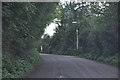
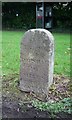
Milestone in Clyst Road
Dating from a time when this would have been the main route out of Topsham. See Image for details.
Image: © Rod Allday
Taken: 17 Aug 2010
0.11 miles
7

Detail of milestone in Clyst Road
The script is difficult to read but reference to old maps suggests that it is '5/8 MILES TO TOPSHAM 16 MILES TO HONITON'. This was presumably the main route out of Topsham when the milestone was placed.
Image: © Rod Allday
Taken: 17 Aug 2010
0.11 miles
8

Old Milestone, Clyst Road (former B3161), Topsham, Parish of Exeter
The milestone is located, 10m South of the turn to Highfield, near a phone box and post box, on the grass verge just off the road, on the East side of the road. Carved stone post, Exeter tombstone design, erected by the Exeter turnpike trust in the 19th century. See also https://www.geograph.org.uk/photo/6072151
Inscription reads:- 5½ / FURLONGS / TO / EXETER / 16 / MILES / TO / HONITON
Milestone Society National ID: DV_HNTP16
Image: © Alan Rosevear
Taken: 18 Apr 2011
0.12 miles
9
Old Milestone, Clyst Road (former B3181), Topsham, Parish of Exeter
The milestone is located, 10m South of the turn to Highfield, near a phone box and post box, on the grass verge just off the road, on the East side of the road. Carved stone post, Exeter tombstone design, erected by the Exeter turnpike trust in the 19th century. See also https://www.geograph.org.uk/photo/6045569
Inscription reads:-
5½
FURLONGS
TO
EXETER
16
MILES
TO
HONITON
Devon & Dartmoor HER.
HER Number: MDV72544 https://www.heritagegateway.org.uk/Gateway/Results_Single.aspx?uid=MDV72544&resourceID=104
Milestone Society National ID: DV_HNTP16
Image: © Alan Rosevear
Taken: 19 Dec 2008
0.12 miles
10
New houses on Carrick Mill, off Newcourt Road
Image: © Rob Purvis
Taken: 20 Aug 2023
0.14 miles