IMAGES TAKEN NEAR TO
Carrick Mill, EX3 0FQ
Introduction
This page details the photographs taken nearby to Carrick Mill, EX3 0FQ by members of the Geograph project.
The Geograph project started in 2005 with the aim of publishing, organising and preserving representative images for every square kilometre of Great Britain, Ireland and the Isle of Man.

There are currently over 7.5m images from over14,400 individuals and you can help contribute to the project by visiting https://www.geograph.org.uk
Image Map
Images are licensed for reuse under creativecommons.org/licenses/by-sa/2.0
Notes
- Clicking on the map will re-center to the selected point.
- The higher the marker number, the further away the image location is from the centre of the postcode.
Image Listing (34 Images Found)
Images are licensed for reuse under creativecommons.org/licenses/by-sa/2.0
Image
Details
Distance
1
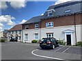
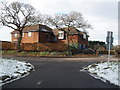
Fake frontage of small apartment block, Carrick Mill, Topsham
Under the bricked window, the door is a fake (the plants in front give it away). This is a small block of affordable homes in an estate developed 2023-2024
Image: © David Smith
Taken: 4 May 2024
0.03 miles
2
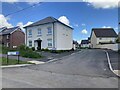
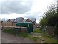
Carrick Mill, a housing estate off Newcourt Road, Topsham
A new estate, developed 2023-2024; of interest is the house with thatch on the right.
Image: © David Smith
Taken: 4 May 2024
0.04 miles
3

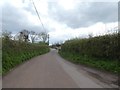
Site for housing development, Newcourt Road, Topsham
Image: © David Smith
Taken: 25 Feb 2021
0.04 miles
5
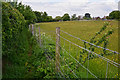
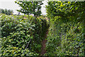
Topsham : Grassy Field & Path
A path heading through a grassy field near Topsham.
Image: © Lewis Clarke
Taken: 16 May 2016
0.09 miles
7
Electricity infrastructure, Newcourt Road, Topsham
Image: © David Smith
Taken: 6 Apr 2020
0.10 miles
8
Topsham : Footpath
Looking along a footpath which heads out beyond Topsham.
Image: © Lewis Clarke
Taken: 16 May 2016
0.11 miles
9

Detail of milestone in Clyst Road
The script is difficult to read but reference to old maps suggests that it is '5/8 MILES TO TOPSHAM 16 MILES TO HONITON'. This was presumably the main route out of Topsham when the milestone was placed.
Image: © Rod Allday
Taken: 17 Aug 2010
0.11 miles
10

Milestone in Clyst Road
Dating from a time when this would have been the main route out of Topsham. See Image for details.
Image: © Rod Allday
Taken: 17 Aug 2010
0.11 miles