IMAGES TAKEN NEAR TO
Parkfield Road, EXETER, EX3 0ET
Introduction
This page details the photographs taken nearby to Parkfield Road, EX3 0ET by members of the Geograph project.
The Geograph project started in 2005 with the aim of publishing, organising and preserving representative images for every square kilometre of Great Britain, Ireland and the Isle of Man.

There are currently over 7.5m images from over14,400 individuals and you can help contribute to the project by visiting https://www.geograph.org.uk
Image Map (Loading...)


Getting Data...Please wait
Leaflet Map data © OpenStreetMap
Images are licensed for reuse under creativecommons.org/licenses/by-sa/2.0
Notes
- Clicking on the map will re-center to the selected point.
- The higher the marker number, the further away the image location is from the centre of the postcode.
Image Listing (661 Images Found)
Images are licensed for reuse under creativecommons.org/licenses/by-sa/2.0
Image
Details
Distance
1
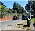
The Shrubbery leading to Majorfield Road, Topsham
The sign faces Holman Way. Turn right here for a path to Majorfield Road.
Image: © Jaggery
Taken: 30 Aug 2016
0.02 miles
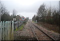
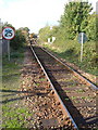
3
The Avocet Line
Looking towards Topsham Station, a passing place on the line.
Image: © M J Richardson
Taken: 12 Jan 2015
0.03 miles
5
Warning sign - Humped Zebra Crossing, Holman Way, Topsham
On the approach to this crossing. https://www.geograph.org.uk/photo/5630404
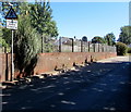
The wall and fence are at the edge of the railway near Topsham station.
Image: © Jaggery
Taken: 30 Aug 2016
0.03 miles
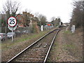
6
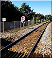
25 mph speed limit on the approach to Topsham railway station
Viewed from this https://www.geograph.org.uk/photo/5630416 level crossing on the Avocet Line.
In the background, the single track becomes two tracks at the edge of the station.
Image: © Jaggery
Taken: 30 Aug 2016
0.03 miles
7
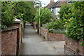
Topsham : Victoria Road
Looking along Victoria Road as it heads from Holman Way.
Image: © Lewis Clarke
Taken: 7 Jul 2017
0.04 miles
8
Looking along the railway line to Topsham Station
Image: © N Chadwick
Taken: 28 Dec 2008
0.04 miles
9
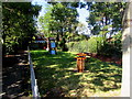
Tappers Close Play Area, Topsham
Children's play area near Topsham railway station.
Image: © Jaggery
Taken: 30 Aug 2016
0.04 miles
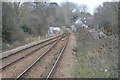
10
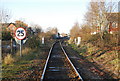
Topsham: the railway line
The single track line approaching Topsham station, seen from the point where it is crossed by Exeter Footpath 64. It runs beside Holman Way, on the left.
Image: © Derek Harper
Taken: 21 Oct 2006
0.04 miles