IMAGES TAKEN NEAR TO
Majorfield Road, EXETER, EX3 0DH
Introduction
This page details the photographs taken nearby to Majorfield Road, EX3 0DH by members of the Geograph project.
The Geograph project started in 2005 with the aim of publishing, organising and preserving representative images for every square kilometre of Great Britain, Ireland and the Isle of Man.

There are currently over 7.5m images from over14,400 individuals and you can help contribute to the project by visiting https://www.geograph.org.uk
Image Map
Images are licensed for reuse under creativecommons.org/licenses/by-sa/2.0
Notes
- Clicking on the map will re-center to the selected point.
- The higher the marker number, the further away the image location is from the centre of the postcode.
Image Listing (669 Images Found)
Images are licensed for reuse under creativecommons.org/licenses/by-sa/2.0
Image
Details
Distance
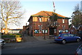
3

Children's playground, off Parkfield Road, Topsham
Image: © David Smith
Taken: 7 Feb 2019
0.04 miles

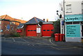
7
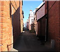
Majorfield Road, Topsham
Narrow dead-end road on the east side of Fore Street.
Image: © Jaggery
Taken: 30 Aug 2016
0.05 miles

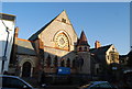
9
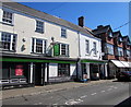
Co-op in Topsham
The Co-operative Food store at 15 Fore Street.
Image: © Jaggery
Taken: 30 Aug 2016
0.05 miles
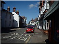
10
Matthews Hall, Topsham
Community building on Fore Street.
Image: © Roger Cornfoot
Taken: 11 Sep 2008
0.05 miles