IMAGES TAKEN NEAR TO
Ilex Close, EXETER, EX2 9UT
Introduction
This page details the photographs taken nearby to Ilex Close, EX2 9UT by members of the Geograph project.
The Geograph project started in 2005 with the aim of publishing, organising and preserving representative images for every square kilometre of Great Britain, Ireland and the Isle of Man.

There are currently over 7.5m images from over14,400 individuals and you can help contribute to the project by visiting https://www.geograph.org.uk
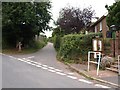
Image Map
Images are licensed for reuse under creativecommons.org/licenses/by-sa/2.0
Notes
- Clicking on the map will re-center to the selected point.
- The higher the marker number, the further away the image location is from the centre of the postcode.
Image Listing (40 Images Found)
Images are licensed for reuse under creativecommons.org/licenses/by-sa/2.0
Image
Details
Distance
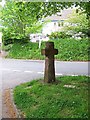
1
Cross at fork in road at Shillingford St George
Image: © David Smith
Taken: 5 Feb 2009
0.02 miles
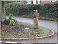
2

Old Milestone in Shillingford St George
Carved stone post by the UC road, in parish of SHILLINGFORD ST GEORGE (TEIGNBRIDGE District), village, 30m Northeast of St George's Terrace, just up from bus stop, on bank above road, on North side of road. Exeter tombstone erected by the Exeter turnpike trust in the 19th century.
Inscription reads:-
3
MILES
FROM
EXETER
Carved benchmark on lower face.
Milestone Society National ID: DV_EXHD03.
Image: © Alan Rosevear
Taken: 19 Apr 2011
0.03 miles
3
Village cross, Shillingford St George
The cross-head and part of shaft is Medieval. The cross was found in a garden at Shillingford Abbot. For a time it was in the churchyard and at a later date it was re-erected on its present site as a war memorial.
Image: © Maigheach-gheal
Taken: 12 May 2009
0.04 miles
5

Old Wayside Cross - moved, in Shillingford St George
Shillingford Cross, old head, shaft and base by the UC road, in parish of Shillingford St George (Teignbridge District), Manstree Road, at junction with Shillingford Road - used as War Memorial, on open grass in the angle of the road junction.
Grade II listed.
List Entry Number: 1309081 https://historicengland.org.uk/listing/the-list/list-entry/1309081
Surveyed
Milestone Society National ID: DVTE_SHI01
Image: © Alan Rosevear
Taken: 14 Apr 2009
0.06 miles
6
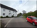
House at road junction, Shillingford St George
Image: © David Smith
Taken: 4 Apr 2020
0.07 miles
7
Junction of Manstree Road in Shillingford St George
The stone cross, which has been moved several times, is part medieval on a modern base.
Image: © David Gearing
Taken: 20 Sep 2013
0.07 miles
8

Shillingford St George from the south
Showing the church and the roofs of Place Farm. The small green huts beyond are poultry accommodation - the white specks on the right are hens.
Image: © Derek Harper
Taken: 19 Apr 2006
0.07 miles
9
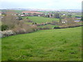
Shillingford St George
The village seen from Shillingford Lane, on high ground to the south-west, with Exeter visible in the distance.
Image: © Derek Harper
Taken: 19 Apr 2006
0.07 miles
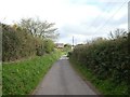
10

Orange Way in Devon and Torbay (184)
The footpath to the church at Shillingford St George leaves the main road through the village here.
Image: © Shazz
Taken: 16 Nov 2011
0.07 miles