IMAGES TAKEN NEAR TO
Ide, EXETER, EX2 9TN
Introduction
This page details the photographs taken nearby to EX2 9TN by members of the Geograph project.
The Geograph project started in 2005 with the aim of publishing, organising and preserving representative images for every square kilometre of Great Britain, Ireland and the Isle of Man.

There are currently over 7.5m images from over14,400 individuals and you can help contribute to the project by visiting https://www.geograph.org.uk
Image Map
Images are licensed for reuse under creativecommons.org/licenses/by-sa/2.0
Notes
- Clicking on the map will re-center to the selected point.
- The higher the marker number, the further away the image location is from the centre of the postcode.
Image Listing (15 Images Found)
Images are licensed for reuse under creativecommons.org/licenses/by-sa/2.0
Image
Details
Distance
1

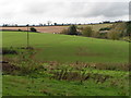
View over Marshall Farm
Marshall Farm and its associated cottages from a lane running along a ridge of the Haldon hills, with the South Devon landscape stretching away towards the mouth of the Exe.
Image: © Derek Harper
Taken: 27 Apr 2006
0.03 miles


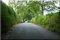
5
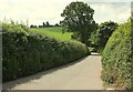
Road past Marshall Farm
A similar view to Image at an earlier season of the year.
Image: © Derek Harper
Taken: 16 Jun 2016
0.22 miles
6
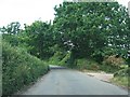
Road passing Westbury (entrance on right)
Image: © David Smith
Taken: 30 May 2011
0.23 miles
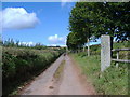

10
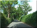
Road north-east of Manstree Cross on the way to Ide
Image: © David Smith
Taken: 30 May 2011
0.23 miles