
IMAGES TAKEN NEAR TO
Tin Lane, EXETER, EX2 9BH
Introduction
This page details the photographs taken nearby to Tin Lane, EX2 9BH by members of the Geograph project.
The Geograph project started in 2005 with the aim of publishing, organising and preserving representative images for every square kilometre of Great Britain, Ireland and the Isle of Man.

There are currently over 7.5m images from over14,400 individuals and you can help contribute to the project by visiting https://www.geograph.org.uk
Image Map
Images are licensed for reuse under creativecommons.org/licenses/by-sa/2.0
Notes
- Clicking on the map will re-center to the selected point.
- The higher the marker number, the further away the image location is from the centre of the postcode.
Image Listing (235 Images Found)
Images are licensed for reuse under creativecommons.org/licenses/by-sa/2.0
Image
Details
Distance
1
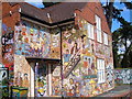
The Loft Club
A youth club on Tin Lane, beside St Thomas' churchyard. The splendid mosaic, featuring local people, is by Elaine Goodwin.
Image: © Derek Harper
Taken: 25 Sep 2006
0.01 miles
2

Tin Lane, St Thomas, Exeter
Now a path for pedestrians and cyclists
Image: © David Smith
Taken: 4 May 2020
0.01 miles
3
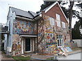
The Loft Club, Exeter
Former community centre, now flats. The mosaic was made by Elaine M. Goodwin and her Group Five between 1987-89.
Image: © John Lord
Taken: 3 Sep 2019
0.01 miles
4

The Loft Club, Tin Lane, St Thomas, Exeter
The mosaic is by Exeter artist Elaine Goodwin. The decoration took two years to complete and shows activities relevant to the community centre, people who met there, and items associated with those people. Ring-a-ring-a-roses includes children of different ethnic backgrounds, dance, sports and musical activities are shown, together with children playing (and being restrained). On the right, the "three graces" and golden apple refer to the Greek myths, and a local artist is shown above the ladies. There is also a kettle for hot drinks and some wildlife.
Image: © David Smith
Taken: 4 May 2020
0.02 miles
5

Tin Lane, Exeter
Hard-to-resist stretch of corrugated iron on this little path that runs past the back of St Thomas churchyard.
Image: © Derek Harper
Taken: 25 Sep 2006
0.02 miles
6
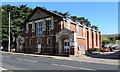
Buller Court, St Thomas, Exeter
Viewed across the B3212 Cowick Street. Managed by Guinness Care and Support Ltd,
Buller Court has 20 self-contained flats to let to older people - new residents must be at least 55 years old.
Image: © Jaggery
Taken: 30 Aug 2016
0.03 miles
7
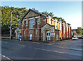
Buller Court, St Thomas, Exeter
A development of 20 self contained retirement flats named after General Sir Redvers Buller but who involved in the Boer War. A nearby public house was named after him too but has changed its name more recently. To my surprise, this arts and craft style building does not have statutory protection
Image: © Chris Allen
Taken: 7 Dec 2021
0.03 miles
8

Buller Court, Exeter
Supported housing, currently run by the Guinness Trust.
Image: © Roger Cornfoot
Taken: 20 May 2010
0.04 miles
9

St Thomas churchyard, Exeter
Monuments in the churchyard, seen from Tin Lane.
Image: © Derek Harper
Taken: 25 Sep 2006
0.04 miles
10

St Thomas's Vicarage, Exeter
Grade II Listed building.
Image: © Chris Allen
Taken: 7 Dec 2021
0.04 miles