IMAGES TAKEN NEAR TO
Waterside, EXETER, EX2 8GU
Introduction
This page details the photographs taken nearby to Waterside, EX2 8GU by members of the Geograph project.
The Geograph project started in 2005 with the aim of publishing, organising and preserving representative images for every square kilometre of Great Britain, Ireland and the Isle of Man.

There are currently over 7.5m images from over14,400 individuals and you can help contribute to the project by visiting https://www.geograph.org.uk
Image Map (Loading...)


Getting Data...Please wait
Leaflet Map data © OpenStreetMap
Images are licensed for reuse under creativecommons.org/licenses/by-sa/2.0
Notes
- Clicking on the map will re-center to the selected point.
- The higher the marker number, the further away the image location is from the centre of the postcode.
Image Listing (875 Images Found)
Images are licensed for reuse under creativecommons.org/licenses/by-sa/2.0
Image
Details
Distance
1

Blocks of flats on Exeter Quay south bank
Image: © David Smith
Taken: 7 Mar 2017
0.00 miles
2
Red River
River Exe running terracotta red from a storm of the previous night.
Image: © Jan Baker
Taken: 4 Dec 2008
0.01 miles
3
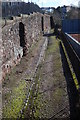
Exeter?s medieval city
First built around 200AD, Exeter’s medieval city wall has encircled the historic town ever since. Well over two-thirds of the circuit survives, more than 2.5 kilometres in circumference, showing evidence of rebuilding and re-use through the medieval period to the present day. This view shows part of the wall with the remains of a cobbled street and drainage gully below it.
Image: © Anthony Volante
Taken: 26 Feb 2010
0.01 miles
4

Flats beside River Exe, reduced flow
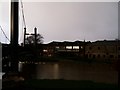
In February 2008, the Environment Agency carried out survey and dredging work on the River Exe between Millers Bridge (SX914926) and Trews Weir (SX924915) which meant that the river level was lowered by between 1 and 2 metres. This is one of a set of pictures showing the river in such unusual circumstances. The pictures of the quay form a panorama showing some of the bedrock on which the quay was built.
On the right is part of the pedestrian bridge in Image
Image: © David Smith
Taken: 15 Feb 2008
0.01 miles
5

Swans on the Exe
Swans on the Exe at dusk, river running terracotta red after the storm of the night before.
Image: © Jan Baker
Taken: 4 Dec 2008
0.01 miles
6

On The Exe
On the footbridge looking toward the Exe bridges.
Image: © Jan Baker
Taken: 4 Dec 2008
0.01 miles

8
Exeter Quay, River Exe in flood
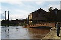
View looking west along Exeter Quay, showing the modern footbridge over one of the medieval leats and floodwater covering the riverside footpath beyond.
Image: © David Smith
Taken: Unknown
0.02 miles
9
Exeter Quay
Image: © Derek Harper
Taken: 21 Jan 2009
0.02 miles
10
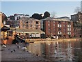
Down the Exe from Mallison Bridge
The scene on the right is similar to that in Image On the left is Clipper Quay.
Image: © Derek Harper
Taken: 21 Jan 2009
0.02 miles