IMAGES TAKEN NEAR TO
Chamberlain Road, EXETER, EX2 8EW
Introduction
This page details the photographs taken nearby to Chamberlain Road, EX2 8EW by members of the Geograph project.
The Geograph project started in 2005 with the aim of publishing, organising and preserving representative images for every square kilometre of Great Britain, Ireland and the Isle of Man.

There are currently over 7.5m images from over14,400 individuals and you can help contribute to the project by visiting https://www.geograph.org.uk
Image Map (Loading...)


Getting Data...Please wait
Leaflet Map data © OpenStreetMap
Images are licensed for reuse under creativecommons.org/licenses/by-sa/2.0
Notes
- Clicking on the map will re-center to the selected point.
- The higher the marker number, the further away the image location is from the centre of the postcode.
Image Listing (417 Images Found)
Images are licensed for reuse under creativecommons.org/licenses/by-sa/2.0
Image
Details
Distance
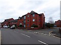
1

Water Lane, junction with Chandlers Walk
Image: © David Smith
Taken: 18 May 2020
0.03 miles
2
The end of Chandlers Walk, Exeter
Modern houses and flats in the former industrial area beside the Exeter Canal - hence the name. Road signs here do not have apostrophes.
Image: © David Smith
Taken: 9 Jan 2015
0.04 miles
3
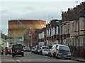
Willeys Avenue, Exeter - plenty of gas for Xmas dinner
No shortage of gas on Christmas Day 2011. The two large spiral-guided gas holders have now been demolished but back then they were still very much in use. I wasn't aware of this view until I realised I had taken it and had to try to work out where I had been standing.
One of my friends who spent his career in research for British Gas has added the following comments regarding the death of the UK gas holder fleet: -
"The UK's gasholders were 'well past their sell-by date' (youngest was 53 by 2011, fleet average age c. 90!) and it's amazing they lasted that long (last decommissioned 2013 just 2 years post-photo) - a tribute to solid Victorian 'fit-for-purpose', 'over-designed' engineering. The fleet of all that replacement 'hi-tech' replacement above-ground gas storage kit (est'd cost c. £850M!) that I organised all that R&D on 1996-2000 never materialised in the end - instead they (the Gas Distribution Co's -'GDNs') 'put extra transmission pipe volume in the ground' upstream at the 7-30 bar pressure level and 'work it hard' for pressure-swing linepack instead. Plus the new LNG tank storage at the Isle of Grain + 2 Milford Haven import terminals helped a bit. Cleverly 'saved a fortune' doing it those ways.
Image: © Chris Allen
Taken: 25 Dec 2011
0.06 miles
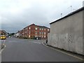
4

Chandlers Walk, Exeter
Part of a housing estate close to Exeter Canal Basin, with street names reflecting maritime links
Image: © David Smith
Taken: 18 May 2020
0.07 miles
5
Mixed business and residential property, Water Lane, Exeter
On the right, the blank wall belongs to a workshop, while opposite is an apartment block
Image: © David Smith
Taken: 4 May 2020
0.07 miles
6
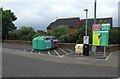
Glass recycling, Haven Banks, Exeter
In a corner of a deserted car park during Covid-19 lockdown
Image: © David Smith
Taken: 4 May 2020
0.07 miles
8
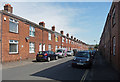
Isca Road, Exeter
"Exeter's first council housing, ultra-plain terraces of forty-two dwellings, completed in 1907".
Image: © Stephen Richards
Taken: 20 Jun 2014
0.08 miles
9
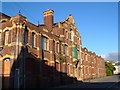
Former electricity generating building, Haven Road, Exeter
Built 1903-5. It faces Image
Image: © Derek Harper
Taken: 3 Oct 2006
0.08 miles
10

Detail of facade, electricity generating building
Classical detailing on Image
Image: © Derek Harper
Taken: 3 Oct 2006
0.08 miles