IMAGES TAKEN NEAR TO
Bridge View Close, EXETER, EX2 7RS
Introduction
This page details the photographs taken nearby to Bridge View Close, EX2 7RS by members of the Geograph project.
The Geograph project started in 2005 with the aim of publishing, organising and preserving representative images for every square kilometre of Great Britain, Ireland and the Isle of Man.

There are currently over 7.5m images from over14,400 individuals and you can help contribute to the project by visiting https://www.geograph.org.uk
Image Map (Loading...)


Getting Data...Please wait
Leaflet Map data © OpenStreetMap
Images are licensed for reuse under creativecommons.org/licenses/by-sa/2.0
Notes
- Clicking on the map will re-center to the selected point.
- The higher the marker number, the further away the image location is from the centre of the postcode.
Image Listing (91 Images Found)
Images are licensed for reuse under creativecommons.org/licenses/by-sa/2.0
Image
Details
Distance
1

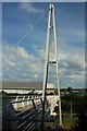
Baker Bridge
Also shown in Image The footbridge, which spans the A379 (a more major undertaking than it sounds, as the two carriageways are 50 metres apart at this point), was built in 2007 at a cost of £650,000. A detailed description is at http://www.lusas.com/case/bridge/baker_bridge.html : "Because the footbridge provides the main pedestrian access to a rugby stadium the design of the slender deck required a detailed time-step analysis to investigate any potential dynamic effects that could be induced by the passage of large crowds".
The bridge was named after Malcolm Baker, a rugby fan and council officer who was involved in the development of Sandy Park, the Exeter Chief's ground which can be seen in the background and to which the bridge leads.
Image: © Derek Harper
Taken: 3 Jun 2017
0.03 miles
2
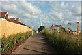
Path to Sandy Park
Showing the path turning left in Image], passing new housing on Bishop's Way on the left, and a building site on the right. Ahead is the Baker Bridge, a footbridge over the A379 Image
Image: © Derek Harper
Taken: 3 Jun 2017
0.03 miles

4
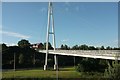
Baker Bridge
A slightly different angle on the cycle- and footbridge shown in Image http://www.lusas.com/case/bridge/baker_bridge.html
Image: © Derek Harper
Taken: 3 Jun 2017
0.04 miles
5
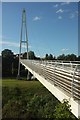
Baker Bridge
A similar view to Image] taken a little further west along the cycle path.
Image: © Derek Harper
Taken: 3 Jun 2017
0.05 miles
6

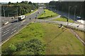
The A379, and the junction for Sandy Park rugby grounds
The blue building in the distance is the new Exeter Ikea store being built
Image: © Rob Purvis
Taken: 31 Jan 2018
0.05 miles
7

The path from Sandy Park heading towards Digby and Sowton station, new houses being built on the left
Image: © Rob Purvis
Taken: 1 Feb 2018
0.05 miles
8

New houses being built, seen from the footpath from Sandy Park rugby grounds
Image: © Rob Purvis
Taken: 1 Feb 2018
0.05 miles
9
Baker Bridge
A reverse view of the bridge shown in Image] http://www.lusas.com/case/bridge/baker_bridge.html .
Image: © Derek Harper
Taken: 3 Jun 2017
0.05 miles
10
Junction on A379
Another view of the junction shown in Image], from further south along Baker Bridge, with the entrance to the Exeter Chiefs' rugby ground on the left. The next bridge along carries the railway line between Newcourt and Digby & Sowton.
Image: © Derek Harper
Taken: 3 Jun 2017
0.05 miles