IMAGES TAKEN NEAR TO
Savoy Street, EXETER, EX2 7NS
Introduction
This page details the photographs taken nearby to Savoy Street, EX2 7NS by members of the Geograph project.
The Geograph project started in 2005 with the aim of publishing, organising and preserving representative images for every square kilometre of Great Britain, Ireland and the Isle of Man.

There are currently over 7.5m images from over14,400 individuals and you can help contribute to the project by visiting https://www.geograph.org.uk
Image Map
Images are licensed for reuse under creativecommons.org/licenses/by-sa/2.0
Notes
- Clicking on the map will re-center to the selected point.
- The higher the marker number, the further away the image location is from the centre of the postcode.
Image Listing (56 Images Found)
Images are licensed for reuse under creativecommons.org/licenses/by-sa/2.0
Image
Details
Distance


3

Ronald gardens, Dart Avenue housing estate, Topsham
Image: © David Smith
Taken: 22 Mar 2021
0.08 miles
4
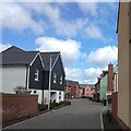
Market Mews, Dart Avenue housing estate, Topsham
Image: © David Smith
Taken: 22 Mar 2021
0.09 miles
5
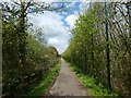
Cycle track, screened on each side
On the left is the M5 on an embankment, on the right, Exeter University sports field
Image: © David Smith
Taken: 6 Apr 2020
0.10 miles
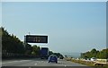

8
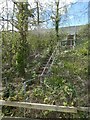
Emergency stairs off M5 (Exminster viaduct)
Image: © David Smith
Taken: 6 Apr 2020
0.11 miles
10

Area cleared for housing, Dart Avenue housing estate, Topsham
Image: © David Smith
Taken: 22 Mar 2021
0.12 miles