IMAGES TAKEN NEAR TO
Dickens Drive, EXETER, EX2 6NS
Introduction
This page details the photographs taken nearby to Dickens Drive, EX2 6NS by members of the Geograph project.
The Geograph project started in 2005 with the aim of publishing, organising and preserving representative images for every square kilometre of Great Britain, Ireland and the Isle of Man.

There are currently over 7.5m images from over14,400 individuals and you can help contribute to the project by visiting https://www.geograph.org.uk
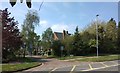
Image Map
Images are licensed for reuse under creativecommons.org/licenses/by-sa/2.0
Notes
- Clicking on the map will re-center to the selected point.
- The higher the marker number, the further away the image location is from the centre of the postcode.
Image Listing (135 Images Found)
Images are licensed for reuse under creativecommons.org/licenses/by-sa/2.0
Image
Details
Distance
1
Tennyson Avenue, cul-de-sac off Shakespeare Road, Exeter
Image: © David Smith
Taken: 11 Apr 2020
0.03 miles
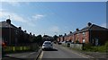
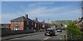
2

Cowper Avenue, cul-de-sac off Shakespeare Road, Exeter
Cowper Avenue is renamed as Dickens Drive at the end by the wall of the barracks
Image: © David Smith
Taken: 11 Apr 2020
0.05 miles
3

Inscribed stone, Topsham Road, Exeter
This stone is in the wall of the barracks (The Rifles are based there). It reads 1874/W D/no 12. It is the corner of the boundary wall; beyond are elegant houses which were formerly for officers and their families.
Image: © David Smith
Taken: 11 Dec 2012
0.07 miles
4
Chaucer Avenue. cul-de-sac off Shakespeare Road, Exeter
Image: © David Smith
Taken: 11 Apr 2020
0.07 miles
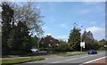
6
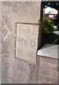
Old Boundary Marker by Topsham Road, Exeter
Estate Boundary Marker - War Department by the UC road, in parish of Exeter (Exeter District), Topsham Road, South East end of Wyvern Barracks, by "Prospect Place", in edge of boundary wall.
Inscription reads:- : 1874 / W ^ D / No-12 :
Surveyed
Milestone Society National ID: DV_EXWB12Wem.
Image: © Alan Rosevear
Taken: 30 Mar 2013
0.07 miles
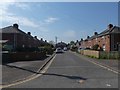
7
King Henrys Road, Exeter
One of a group of small roads inspired by the Garden City movement between WW1 and WW2
Image: © David Smith
Taken: 25 Apr 2020
0.08 miles
8
Cul-de-sac off Shakespeare Road, Exeter
This cul-de-sac is part of Shakespeare Road, Exeter
Image: © David Smith
Taken: 11 Apr 2020
0.09 miles
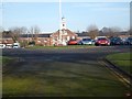
10
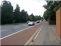
Topsham Road, Exeter
The A3015 being the main route out of Exeter to the south east.
Image: © Bill Boaden
Taken: 29 Jun 2011
0.09 miles