IMAGES TAKEN NEAR TO
Topsham Road, EXETER, EX2 6EX
Introduction
This page details the photographs taken nearby to Topsham Road, EX2 6EX by members of the Geograph project.
The Geograph project started in 2005 with the aim of publishing, organising and preserving representative images for every square kilometre of Great Britain, Ireland and the Isle of Man.

There are currently over 7.5m images from over14,400 individuals and you can help contribute to the project by visiting https://www.geograph.org.uk
Image Map (Loading...)


Getting Data...Please wait
Leaflet Map data © OpenStreetMap
Images are licensed for reuse under creativecommons.org/licenses/by-sa/2.0
Notes
- Clicking on the map will re-center to the selected point.
- The higher the marker number, the further away the image location is from the centre of the postcode.
Image Listing (111 Images Found)
Images are licensed for reuse under creativecommons.org/licenses/by-sa/2.0
Image
Details
Distance
1

Last Orders have been called
A derelict Public House on the Topsham Road.
Image: © Anthony Vosper
Taken: 16 Oct 2010
0.01 miles
2
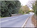
A3015 (Topsham Road) bridge over Northbrook, Exeter
Image: © David Smith
Taken: 6 Nov 2016
0.05 miles
3
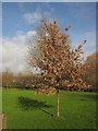
Oak, Ludwell Valley Park
This little oak tree seems to be managing to hang on to its dead leaves through the winter - so does this marcescence mean that this is a pin oak (Quercus palustris)?
Image: © Derek Harper
Taken: 4 Feb 2013
0.07 miles
4
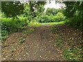
Footpath approaching a Main Road
The end of the public footpath from the Ludwell Valley Park in Exeter, Devon as it approaches the A3015 main road.
Image: © John P Reeves
Taken: 4 Jul 2022
0.07 miles
5
Felled tree, Northbrook Park
The sad remains of the oak tree shown leaning over the bank in Image Again, taken looking upstream from the bridge seen in Image A further footbridge can be seen 60 metres upstream.
Image: © Derek Harper
Taken: 4 Feb 2013
0.07 miles
6

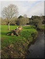
Ludwell Valley Park
The main path has been rerouted away from the Northbrook (right) across the playing fields. The linear park extends some way up the stream's valley and to the east to include a variety of habitats, among them farmland http://www.exeter.gov.uk/CHttpHandler.ashx?id=15784&p=0 .
Image: © Derek Harper
Taken: 4 Feb 2013
0.08 miles
7
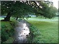
Northbrook
The stream, with a little associated morning mist, flowing towards the camera past the Approach Golf Course in eastern Exeter. Taken from Image
Image: © Derek Harper
Taken: 27 Oct 2006
0.08 miles
8
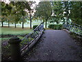
Bridge over the Northbrook
This bridge carries Exeter Footpath 49 over the Northbrook from the grounds of the crematorium to Northbrook Park Approach Golf Course.
Image: © Derek Harper
Taken: 27 Oct 2006
0.09 miles
9
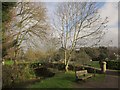
Bridge, Northbrook Park
A different view of the footbridge shown in http://www.geograph.org.uk/search.php?i=39645945 . The seat seems to have arrived in between those two photos being taken. The Northbrook is flowing to the left.
Image: © Derek Harper
Taken: 4 Feb 2013
0.09 miles
