IMAGES TAKEN NEAR TO
Cliff Bastin Close, EXETER, EX2 5QW
Introduction
This page details the photographs taken nearby to Cliff Bastin Close, EX2 5QW by members of the Geograph project.
The Geograph project started in 2005 with the aim of publishing, organising and preserving representative images for every square kilometre of Great Britain, Ireland and the Isle of Man.

There are currently over 7.5m images from over14,400 individuals and you can help contribute to the project by visiting https://www.geograph.org.uk
Image Map
Images are licensed for reuse under creativecommons.org/licenses/by-sa/2.0
Notes
- Clicking on the map will re-center to the selected point.
- The higher the marker number, the further away the image location is from the centre of the postcode.
Image Listing (27 Images Found)
Images are licensed for reuse under creativecommons.org/licenses/by-sa/2.0
Image
Details
Distance
1

Woodwater Lane St, Loye's
Dead leaves nestling in some levely green hedgerow plants.
Image: © Jan Baker
Taken: 11 Dec 2008
0.08 miles
2
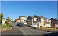
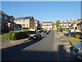
Spinney Close, Exeter
Part of a large housing estate
Image: © David Smith
Taken: 20 May 2020
0.10 miles
3
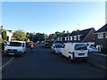
Dusk, Quarry Park Road, Exeter
This road through the housing estate is lined with parked cars overnight
Image: © David Smith
Taken: 20 May 2020
0.12 miles
4
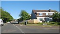
Quarry Lane junction with Quarry Park Road, Exeter
Image: © David Smith
Taken: 20 May 2020
0.14 miles
5
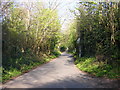
Quarry Lane
A narrow lane, often used as a short cut by motorists when the main road is busy. The Rydon Lane end is 'no entry' but the lane is not one-way - presumably at one time there was a side entry into it.
Image: © Brian Henley
Taken: 16 Apr 2008
0.14 miles
6
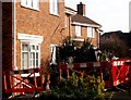
House Demolition 2
In Grecian Way just off Quarry Lane, Exeter, A car smashed into this house demolishing the corner of the ground floor (car just removed)
Image: © Jan Baker
Taken: 2 Jan 2009
0.15 miles
7
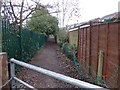
Access track off Woodwater Lane, Exeter
This track gives access to an open recreational space bounded by the local primary school and the gardens of local houses in Quarry Park Road and Plumtree Drive
Image: © David Smith
Taken: 21 Jan 2016
0.15 miles
8
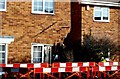
House Demolition
Grecian Way near junction with Quarry Lane, Exeter, the ground floor corner of this house was demolished by a car (car had been removed)
Image: © Jan Baker
Taken: 2 Jan 2009
0.15 miles
9
Farm Close, Exeter
This area of Exeter was the site of several stone quarries. Farm Close is built on the site of open fields above the largest such quarry
Image: © David Smith
Taken: 20 May 2020
0.16 miles
10

Grecian Way, Exeter
Road leading to a cluster of modern houses. Grecian Way takes its name from the nickname of Exeter City Football Club, "The Grecians"; however there is no agreed reason for this nickname
Image: © David Smith
Taken: 21 Jan 2016
0.16 miles